IMAGES TAKEN NEAR TO
High Street, TADWORTH, KT20 5RB
Introduction
This page details the photographs taken nearby to High Street, KT20 5RB by members of the Geograph project.
The Geograph project started in 2005 with the aim of publishing, organising and preserving representative images for every square kilometre of Great Britain, Ireland and the Isle of Man.

There are currently over 7.5m images from over14,400 individuals and you can help contribute to the project by visiting https://www.geograph.org.uk
Image Map
Images are licensed for reuse under creativecommons.org/licenses/by-sa/2.0
Notes
- Clicking on the map will re-center to the selected point.
- The higher the marker number, the further away the image location is from the centre of the postcode.
Image Listing (64 Images Found)
Images are licensed for reuse under creativecommons.org/licenses/by-sa/2.0
Image
Details
Distance
1
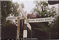
Old Direction Sign - Signpost by the B2220, Tadworth Street, Banstead Parish
Lost finial - 4 arms; Surrey wooden arm by the B2220, in parish of Banstead (Reigate and Banstead District), Tadworth Street junction with High Street, opposite B290 Station Approach Road, on verge, West of railway bridge.
Surveyed
Milestone Society National ID: SY_TQ2355
Image: © Milestone Society
Taken: Unknown
0.03 miles
2
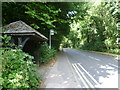
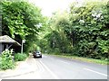
Bus shelter on Tadworth Street, Tadworth
This is Tadworth Street on the edge of the wooded Banstead Heath. The bus shelter is well hidden in the trees.
Image: © Marathon
Taken: 14 Aug 2013
0.09 miles
3
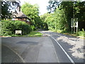
Tadworth Street, Tadworth
This is Tadworth Street, just after it leaves Banstead Heath. Heathside Court is on the left.
Image: © Marathon
Taken: 14 Aug 2013
0.10 miles
4
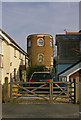
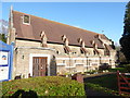
Tadworth Water Tower
Originally built for the Sutton Water Company in 1898. It had ceased to be a water tower by 1925, with the tank removed to the company's Woodmansterne depot, for oil storage. The tower itself was sold and was converted to residential use. It is locally listed.
Image: © Ian Capper
Taken: 24 Apr 2010
0.11 miles
5
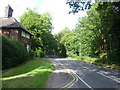
Tadworth Street, Tadworth
This is Tadworth Street, just after it leaves Banstead Heath. The entrance to Heathside Court is just behind.
Image: © Marathon
Taken: 14 Aug 2013
0.11 miles
6
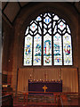
Church of the Good Shepherd, Tadworth: chancel
The chancel and east window. For a brief history see Image
Image: © Stephen Craven
Taken: 23 Feb 2010
0.11 miles
7
The Good Shepherd, Tadworth: early January 2017
Image: © Basher Eyre
Taken: 2 Jan 2017
0.11 miles
8
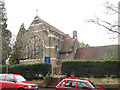
Church of the Good Shepherd, Tadworth: east end
The east end of the church faces Station Approach Road; the building is on the corner of The Avenue. The church (Anglican) was built in 1912 to designs by Charles Barry and is not listed.
Image: © Stephen Craven
Taken: 23 Feb 2010
0.12 miles
10
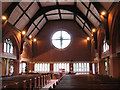
Church of the Good Shepherd, Tadworth: nave
The interior of the church, looking west. For a brief history see Image
Image: © Stephen Craven
Taken: 23 Feb 2010
0.12 miles