IMAGES TAKEN NEAR TO
Tattenham Way, TADWORTH, KT20 5NF
Introduction
This page details the photographs taken nearby to Tattenham Way, KT20 5NF by members of the Geograph project.
The Geograph project started in 2005 with the aim of publishing, organising and preserving representative images for every square kilometre of Great Britain, Ireland and the Isle of Man.

There are currently over 7.5m images from over14,400 individuals and you can help contribute to the project by visiting https://www.geograph.org.uk
Image Map
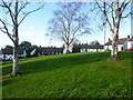
Images are licensed for reuse under creativecommons.org/licenses/by-sa/2.0
Notes
- Clicking on the map will re-center to the selected point.
- The higher the marker number, the further away the image location is from the centre of the postcode.
Image Listing (18 Images Found)
Images are licensed for reuse under creativecommons.org/licenses/by-sa/2.0
Image
Details
Distance
2
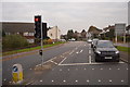
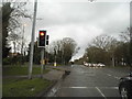
A240 - B2221 turning for Epsom Downs
It is odd that the M25 is signed straight on, as it is closer going in the opposite direction. However, the triangle may indicate a diversionary route in the event of the motorway being blocked.
Image: © Robin Webster
Taken: 1 Apr 2012
0.03 miles
3
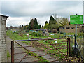
Tattenham Way allotments
At the south end of a municipal block of land, most of which is Nork Park.
Image: © Robin Webster
Taken: 23 Nov 2010
0.04 miles
4
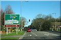
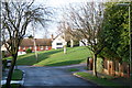
Reigate Road at the junction of Great Tattenhams
Image: © David Howard
Taken: 29 Mar 2015
0.04 miles
5
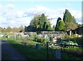
Tattenham Way Allotments
Tattenham Way Allotments are at the western end of Tattenham Way Recreation Ground.
Image: © Marathon
Taken: 4 Nov 2013
0.05 miles
6
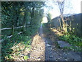
Church Lane
Church Lane comes from Reigate Road (A240) and passes between Nork Park and Tattenham Way Recreation Ground as a path before becoming The Drive on its way to Brighton Road (A217).
Image: © Marathon
Taken: 4 Nov 2013
0.07 miles
7
Shawley Crescent
Open space in Shawley Crescent seen from its junction with Great Tattenhams: the modern green is a remnant of the field behind Great Burgh, a manorial settlement on the Reigate Road where Home Farm Close now stands.
Image: © Hugh Craddock
Taken: 27 Dec 2013
0.15 miles
8
Shawley Crescent
This small green is on Shawley Crescent off Great Tattenhams.
Image: © Marathon
Taken: 4 Nov 2013
0.16 miles
9
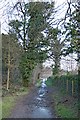
Church Lane
Church Lane: now a public bridleway Banstead 23 and townpath T9021, but formerly the way between Great Burgh, a manorial settlement on the Reigate Road, and Banstead village and Image To the north of the path is Nork Park; to the south are the Image
Image: © Hugh Craddock
Taken: 27 Dec 2013
0.16 miles