IMAGES TAKEN NEAR TO
Beatrice Square, TADWORTH, KT20 5FT
Introduction
This page details the photographs taken nearby to Beatrice Square, KT20 5FT by members of the Geograph project.
The Geograph project started in 2005 with the aim of publishing, organising and preserving representative images for every square kilometre of Great Britain, Ireland and the Isle of Man.

There are currently over 7.5m images from over14,400 individuals and you can help contribute to the project by visiting https://www.geograph.org.uk
Image Map
Images are licensed for reuse under creativecommons.org/licenses/by-sa/2.0
Notes
- Clicking on the map will re-center to the selected point.
- The higher the marker number, the further away the image location is from the centre of the postcode.
Image Listing (11 Images Found)
Images are licensed for reuse under creativecommons.org/licenses/by-sa/2.0
Image
Details
Distance
1
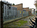
Electricity substation, end of Chetwode Road
The end of the road is at the right, where it meets wooded common land further right. One of the transformers was making a loud 50 Hz hum which carried for some distance, even into the woodland.
Image: © Robin Webster
Taken: 23 Nov 2010
0.06 miles
2
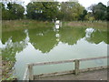
Marbles Pond
A surprising find in the middle of a housing estate, this pond is presumably a relic from the time when this was part of Burgh Heath. It is to be found down Marbles Way next to Merefield Gardens. A heron is sitting on the notice in the middle of the pond.
Image: © Marathon
Taken: 7 Nov 2013
0.13 miles
3
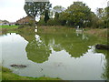
Marbles Pond, Burgh Heath
A surprising find in the middle of a housing estate, this pond is presumably a relic from the time when this was part of Burgh Heath. It is to be found down Marbles Way next to Merefield Gardens. A heron is sitting on the notice in the middle of the pond.
Image: © Marathon
Taken: 7 Nov 2013
0.13 miles
4
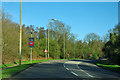
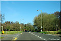
A240, Burgh Heath
Crossing The Common, partly open access land.
Image: © Robin Webster
Taken: 1 Apr 2012
0.20 miles
5

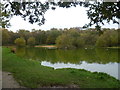
Looking across the pond at Burgh Heath
This pond is close to Brighton Road (A217) near the junction with Reigate Road (A240). To the west and south is the woodland of Burgh Heath. The houses of The Green can be seen on the other side of the pond.
Image: © Marathon
Taken: 7 Nov 2013
0.20 miles
6
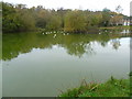
Pond at Burgh Heath
This pond is close to Brighton Road (A217) near the junction with Reigate Road (A240). To the west and south is the woodland of Burgh Heath.
Image: © Marathon
Taken: 7 Nov 2013
0.20 miles
7
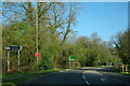
A240, Burgh Heath
There are two turnings to the right to an Asda superstore. The first is for service vehicles only.
Image: © Robin Webster
Taken: 1 Apr 2012
0.20 miles
8
A240, Burgh Heath
Crossing The Common, open access land.
Image: © Robin Webster
Taken: 1 Apr 2012
0.20 miles
9
Pond at Burgh Heath
This pond is close to Brighton Road (A217) near the junction with Reigate Road (A240). To the west and south is the woodland of Burgh Heath.
Image: © Marathon
Taken: 7 Nov 2013
0.21 miles
10
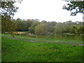
On Burgh Heath
This view is close to The Green and not far from Brighton Road (A217) near the junction with Reigate Road (A240). To the west and south beyond the pond is the woodland of Burgh Heath.
Image: © Marathon
Taken: 7 Nov 2013
0.21 miles