IMAGES TAKEN NEAR TO
Motts Hill Lane, TADWORTH, KT20 5BH
Introduction
This page details the photographs taken nearby to Motts Hill Lane, KT20 5BH by members of the Geograph project.
The Geograph project started in 2005 with the aim of publishing, organising and preserving representative images for every square kilometre of Great Britain, Ireland and the Isle of Man.

There are currently over 7.5m images from over14,400 individuals and you can help contribute to the project by visiting https://www.geograph.org.uk
Image Map
Images are licensed for reuse under creativecommons.org/licenses/by-sa/2.0
Notes
- Clicking on the map will re-center to the selected point.
- The higher the marker number, the further away the image location is from the centre of the postcode.
Image Listing (26 Images Found)
Images are licensed for reuse under creativecommons.org/licenses/by-sa/2.0
Image
Details
Distance
1
Running the Perch (2)
For the background to the race title see Image
Image: © Stephen Craven
Taken: 31 Jan 2010
0.07 miles
2
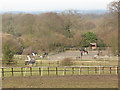
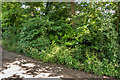
Wildwoods Riding Centre
A view from the public footpath off Motts Hill Lane.
Image: © Stephen Craven
Taken: 31 Jan 2010
0.09 miles
3
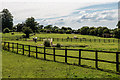
Wildwoods Riding Centre
Paddocks on the outskirts of Tadworth.
Image: © Ian Capper
Taken: 8 Jun 2014
0.10 miles
4
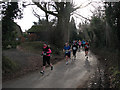
Running the Perch (3)
For the background to the race title see Image Here the runners are coming down Ebbisham Lane.
Image: © Stephen Craven
Taken: 31 Jan 2010
0.12 miles
5
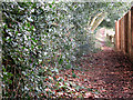
Footpath to Motts Hill Lane
A footpath between a holly hedge on one side and a garden fence on the other.
Image: © Stephen Craven
Taken: 31 Jan 2010
0.13 miles
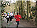
6
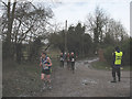
Running the Perch
A few of the hundreds of hardy runners competing in the Epsom Perch race in wintry conditions. According to the website http://www.epsomoddballs.org/perch.php , the race covers a distance of 2000 perches (11000 yards or just over 10km).
Image: © Stephen Craven
Taken: 1 Feb 2010
0.14 miles
7
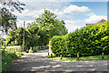
Off Motts Lane
The bridleway between the two fences to the left of centre lead towards Walton Downs.
Image: © Ian Capper
Taken: 8 Jun 2014
0.14 miles
8
Coal Tax Post no 135
This Coal Tax Post (no 135 on the list linked to below) is hidden in a laurel hedge on the edge of a garden alongside Motts Hill Lane. Its situation means that it is not possible to photograph without some foliage getting in the way.
For a photo of its situation see Image
Image: © Ian Capper
Taken: 8 Jun 2014
0.16 miles
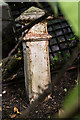
9
Coal Tax Post no 135
Hidden in this hedge alongside Motts Hill Lane is a Coal Tax Post (no 135 on the list linked to below) is hidden in a laurel hedge - not the easiest one to locate.
For a close up of the post itself, see Image
Image: © Ian Capper
Taken: 8 Jun 2014
0.16 miles
10
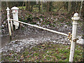
Coal Tax post no. 136
The white post is a coal tax post http://en.wikipedia.org/wiki/Coal_tax_post at a point where several rights of way converge. Although it appears not to coincide with any present day civil administrative boundary, it does lie on the boundary between the Anglican dioceses of Southwark (in which Tadworth lies) and Guildford (which includes Walton-on-the-Hill).
Image: © Stephen Craven
Taken: 31 Jan 2010
0.16 miles