IMAGES TAKEN NEAR TO
Colne Court, EPSOM, KT19 9PT
Introduction
This page details the photographs taken nearby to Colne Court, KT19 9PT by members of the Geograph project.
The Geograph project started in 2005 with the aim of publishing, organising and preserving representative images for every square kilometre of Great Britain, Ireland and the Isle of Man.

There are currently over 7.5m images from over14,400 individuals and you can help contribute to the project by visiting https://www.geograph.org.uk
Image Map
Images are licensed for reuse under creativecommons.org/licenses/by-sa/2.0
Notes
- Clicking on the map will re-center to the selected point.
- The higher the marker number, the further away the image location is from the centre of the postcode.
Image Listing (53 Images Found)
Images are licensed for reuse under creativecommons.org/licenses/by-sa/2.0
Image
Details
Distance
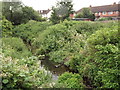
1
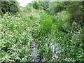
Hogsmill River near the confluence with the Bonesgate Stream
Maps of the 19th century show the Hogsmill Valley as a patchwork of fields, those close to the river being meadows whilst arable fields lay further away out of the reach of flooding. The Hogsmill is a chalk stream since most of its water comes from the dip-slope springs at Ewell. At the turn of the 20th century this was still a large area of farmland. It has been saved from development by virtue of being the floodplain of the Hogsmill. It now forms a wildlife corridor followed by the London LOOP on its way to Kingston Bridge.
This view from a footbridge at the southern edge of Tolworth Court Farm Fields looks upriver towards Ewell. The Bonesgate Stream flows into the Hogsmill just behind. The Bonesgate Stream rises at Malden Rushett in the far south of the Royal Borough of Kingston upon Thames. In the early years of the 20th century the Bonesgate Stream was known as ‘The Rythe’ a name which is today attached to a totally different stream to the west of the Borough. The origin of the name ‘Bonesgate’ stems from the Old English Bone or Bonne which would have been a proper name, and gate meaning a gap in a wall, hence a gap in a wall belonging to Bonne. The name has nothing to do with plague pits.
The London LOOP follows the left hand bank of the Hogsmill here.
Image: © Marathon
Taken: 7 Aug 2013
0.06 miles
2
Hogsmill River, near Tolworth
A view upstream along the Hogsmill River, as it flows towards the Greater London boundary.
Image: © Malc McDonald
Taken: 25 Feb 2023
0.06 miles
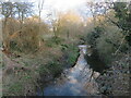
4
Hogsmill River, Ewell
A very narrow stream with the level of a river in its name. Here it flows through parkland.
Image: © Colin Smith
Taken: 3 Jul 2012
0.07 miles
5
Ewell, Hogsmill River
Leafy stream flowing towards the Green Belt between Ewell and Kingston-upon-Thames.
Image: © Colin Smith
Taken: 3 Jul 2012
0.07 miles
6
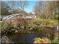
Bridge Over the Bonesgate Stream
The Bonesgate Stream is the longest tributary of the Hogsmill River. It rises near Chessington and flows for about 5km to the confluence here beside the London Loop path.
Image: © Des Blenkinsopp
Taken: 26 Mar 2012
0.07 miles
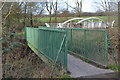
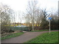
7
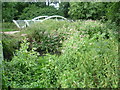
Bridges near Tolworth
Bridges taking paths across the Hogsmill River and Bonesgate Stream. Bonesgate Stream forms the county boundary between Surrey and Greater London. The white bridge therefore crosses from Surrey into Greater London.
Image: © Malc McDonald
Taken: 25 Feb 2023
0.07 miles
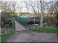
8
London LOOP near Tolworth
A path leading off the London LOOP near Tolworth. The path junction is within Surrey but the white bridge in the background takes a path across Bonesgate Stream, which forms the boundary with Greater London. The green bridge crosses another river, the Hogsmill River.
Image: © Malc McDonald
Taken: 25 Feb 2023
0.07 miles
9
Looking across the Hogsmill River and the Bonesgate Stream
Maps of the 19th century show the Hogsmill Valley as a patchwork of fields, those close to the river being meadows whilst arable fields lay further away out of the reach of flooding. The Hogsmill is a chalk stream since most of its water comes from the dip-slope springs at Ewell. At the turn of the 20th century this was still a large area of farmland. It has been saved from development by virtue of being the floodplain of the Hogsmill.
This view from next to a footbridge at the southern edge of Tolworth Court Farm Fields looks across the Hogsmill River and beyond that to a steel bridge over the Bonesgate Stream. The Bonesgate Stream flows into the Hogsmill just out of the picture to the right. The Bonesgate Stream rises at Malden Rushett in the far south of the Royal Borough of Kingston upon Thames. In the early years of the 20th century the Bonesgate Stream was known as ‘The Rythe’ a name which is today attached to a totally different stream to the west of the Borough. The origin of the name ‘Bonesgate’ stems from the Old English Bone or Bonne which would have been a proper name, and gate meaning a gap in a wall, hence a gap in a wall belonging to Bonne. The name has nothing to do with plague pits.
This photograph is taken from the London LOOP on its way to Kingston Bridge.
Image: © Marathon
Taken: 7 Aug 2013
0.07 miles
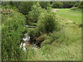
10
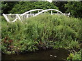
Hogsmill River
The Hogsmill here is just upstream of the inter-war Tolworth Court Bridge. The white arched bridge carries a footpath over the Bonesgate Stream and into grassland forming the Green Belt between Ewell and Kingston-upon-Thames.
Image: © Colin Smith
Taken: 3 Jul 2012
0.07 miles