IMAGES TAKEN NEAR TO
Woodcote Park Road, EPSOM, KT18 7EX
Introduction
This page details the photographs taken nearby to Woodcote Park Road, KT18 7EX by members of the Geograph project.
The Geograph project started in 2005 with the aim of publishing, organising and preserving representative images for every square kilometre of Great Britain, Ireland and the Isle of Man.

There are currently over 7.5m images from over14,400 individuals and you can help contribute to the project by visiting https://www.geograph.org.uk
Image Map
Images are licensed for reuse under creativecommons.org/licenses/by-sa/2.0
Notes
- Clicking on the map will re-center to the selected point.
- The higher the marker number, the further away the image location is from the centre of the postcode.
Image Listing (17 Images Found)
Images are licensed for reuse under creativecommons.org/licenses/by-sa/2.0
Image
Details
Distance
2
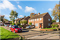
Whitmores Close
1950s cul-de-sac off Dorking Road.
Image: © Ian Capper
Taken: 27 Oct 2017
0.14 miles
3
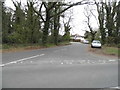
Loop Road at the junction of Wilmerhatch Lane
Image: © David Howard
Taken: 30 Mar 2014
0.15 miles
4
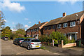
Whitmores Close
1950s cul-de-sac off Dorking Road.
Image: © Ian Capper
Taken: 27 Oct 2017
0.15 miles
5
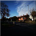
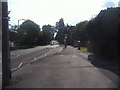
Dorking Road
Houses on the A24 close to the end of the urban sprawl.
Image: © James Emmans
Taken: 14 Nov 2019
0.15 miles
6
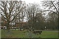
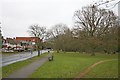
Woodcote Green
Compare with this photo taken in 1890: http://www.francisfrith.com/epsom/photos/woodcote-green-1890_25996/ and http://www.geograph.org.uk/stuff/frith.php?id=2741461 . It seems possible that the tree in the near left foreground is the same as appears in the 1890 photo, while the area to the right of Woodcote Hurst (which now forms part of the Millennium Green) is quite heavily wooded, but was largely open in 1890: indeed, although no animals are visible in the 1890 photo, it seems probable that the green was being grazed by commoning animals off the almost contiguous Epsom Common at this time, which would have kept the land open and largely free from scrub.
Image: © Hugh Craddock
Taken: 26 Dec 2011
0.16 miles
7
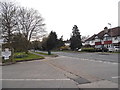
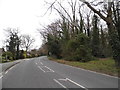
Woodcote Green Road at the junction of Woodcote Hurst
Image: © David Howard
Taken: 30 Mar 2014
0.16 miles
8
Woodcote Green
Compare with this photo taken in 1890: http://www.francisfrith.com/epsom/photos/woodcote-green-1890_25997/ and http://www.geograph.org.uk/stuff/frith.php?id=2740812 . The bus stop is of course new, as is all of the development on the north side of Woodcote Green Road, including Epsom General Hospital in the distance. It's unlikely that the bench is in exactly the same position as 120 years ago, but it doesn't seem to have moved much.
Image: © Hugh Craddock
Taken: 26 Dec 2011
0.17 miles
9
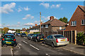
Ebbisham Road
1930s housing. The name commemorates the original name of Epsom, Ebba's Ham, later Evesham or Ebbisham. Confusingly, the name Ebbisham Road applies to both a hexagon shaped circuit of houses together with two spurs off it, one to the south (seen here) and one to the west.
Image: © Ian Capper
Taken: 27 Oct 2017
0.19 miles