IMAGES TAKEN NEAR TO
Ashley Road, EPSOM, KT18 7BY
Introduction
This page details the photographs taken nearby to Ashley Road, KT18 7BY by members of the Geograph project.
The Geograph project started in 2005 with the aim of publishing, organising and preserving representative images for every square kilometre of Great Britain, Ireland and the Isle of Man.

There are currently over 7.5m images from over14,400 individuals and you can help contribute to the project by visiting https://www.geograph.org.uk
Image Map
Images are licensed for reuse under creativecommons.org/licenses/by-sa/2.0
Notes
- Clicking on the map will re-center to the selected point.
- The higher the marker number, the further away the image location is from the centre of the postcode.
Image Listing (17 Images Found)
Images are licensed for reuse under creativecommons.org/licenses/by-sa/2.0
Image
Details
Distance
1
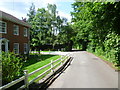
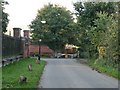
Chalk Lane on the approach to Epsom
Chalk Lane is an old route leading from the centre of Epsom up to Epsom Downs. It is used by both cars and pedestrians but fortunately is not too busy. Here it has just passed Durdans and its associated buildings on the way into Epsom.
Image: © Marathon
Taken: 14 May 2014
0.04 miles
3
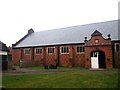
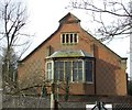
Historic indoor riding school at The Durdans stables
Designed by Victorian Arts & Crafts architect George Devey for Lord Rosebery. The date over the entrance is 1881. This is a Grade II* listed structure.
Image: © Jonathan Hutchins
Taken: 28 Jun 2013
0.09 miles
4
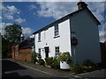
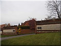
Cottage in Chalk Lane
Chalk Lane is an old route leading from the centre of Epsom up to Epsom Downs. It is used by both cars and pedestrians but fortunately is not too busy. Here it has nearly reached Woodcote Road on the way into Epsom, passing another attractive group of buildings. Worple Road is on the right.
Image: © Marathon
Taken: 14 May 2014
0.12 miles
5
Chalk Lane gate
This recently erected barrier replaces a gate which previously stood here, and which is intended to discourage through traffic (it is not actually locked). To the right of the barrier is a gap for pedestrians, cyclists and horse riders, with padding on the post for the protection of race horses. To the left is the entrance to Durdans and the Lavendou livery yard (the latter is currently subject to a proposal for redevelopment).
Image: © Hugh Craddock
Taken: 12 Oct 2008
0.12 miles
6
Victorian indoor Riding School, The Durdans, Chalk Lane
Image: © norman hyett
Taken: 3 Feb 2008
0.13 miles
7
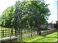
The wrought iron gates to Durdans
Durdans was built 1764-8 and was much added to in the 19th century. The wrought iron gates came from Canons in Middlesex, the seat of the Duke of Chandos. They are seen here from Chalk Lane.
Image: © Marathon
Taken: 14 May 2014
0.14 miles
8
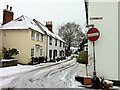
Chalk Lane
Chalk Lane north towards The Ladas from the junction with Worple Road. On the left hand side of the road are a number of weatherboarded cottages characteristic of Epsom.
Image: © Hugh Craddock
Taken: 5 Feb 2012
0.14 miles
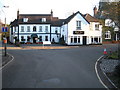
9
The entrance to Berkeley Place, Woodcote
Image: © David Howard
Taken: 30 Mar 2014
0.15 miles
10
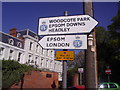
RAC fingerposts, Woodcote Green Road
The RAC officially stopped making road signs in 1964 with the new Worboys designs, these may be the only ones made since still in place. These are exceptional as by RAC offices.
Image: © David Howard
Taken: 26 Apr 2009
0.16 miles