IMAGES TAKEN NEAR TO
Langley Lane, EPSOM, KT18 6PA
Introduction
This page details the photographs taken nearby to Langley Lane, KT18 6PA by members of the Geograph project.
The Geograph project started in 2005 with the aim of publishing, organising and preserving representative images for every square kilometre of Great Britain, Ireland and the Isle of Man.

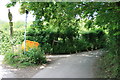
There are currently over 7.5m images from over14,400 individuals and you can help contribute to the project by visiting https://www.geograph.org.uk
Image Map
Images are licensed for reuse under creativecommons.org/licenses/by-sa/2.0
Notes
- Clicking on the map will re-center to the selected point.
- The higher the marker number, the further away the image location is from the centre of the postcode.
Image Listing (20 Images Found)
Images are licensed for reuse under creativecommons.org/licenses/by-sa/2.0
Image
Details
Distance
1
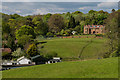
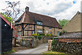
Woodside, Langley Lane
Woodside cottage seen from public footpath 508 Headley across fields above Tumber Farm. Woodside sits on the eastern end of Langley Lane, a byway open to all traffic (but in fact, closed to motor vehicles) between Leech Lane and Tumber Street.
Image: © Hugh Craddock
Taken: 16 Oct 2010
0.02 miles
2
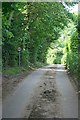
Langley Lane, Headley
A byway (BY545) curving along the foot of Nower Wood, and doubtless once an important local route.
Image: © Derek Harper
Taken: 3 Feb 2011
0.03 miles
3
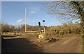
Lane junction, Headley
Langley Lane (byway BY545) heads left. I think this is where Tumber Street (immediate foreground) becomes Slough Lane (right). That must one of the smallest greens in Surrey, though it nevertheless hosts two notices and a salt box.
Image: © Derek Harper
Taken: 3 Feb 2011
0.05 miles
4
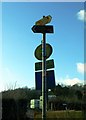
Collection of road signs, Headley, Surrey
Image: © nick macneill
Taken: 11 Jan 2013
0.05 miles
5
Slough Lane, Tumber Street and Langley Lane
A junction of three minor roads: Slough Lane (ahead), Langley Lane (to the left, byway Headley 545, which is closed to motor vehicles), and Tumber Street (from which the photograph is taken). The triangular grass island in the centre of the junction is just big enough to accommodate two salt bins (one old, one new), and the required 'no motor vehicles' sign. Plus, on another post, a Surrey cycleway sign.
Image: © Hugh Craddock
Taken: 1 Jun 2014
0.06 miles
6
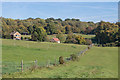
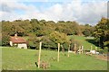
Paddocks
Horse paddocks above Tumber Street.
Image: © Ian Capper
Taken: 5 Oct 2018
0.07 miles
7
Paddocks
Paddocks near Tumber Farm Stables, with Tumber House in the background.
Image: © Ian Capper
Taken: 29 Apr 2017
0.10 miles
8
Slough Lane
Slough Lane is a quiet lane serving the former farms around the back of Headley village: it connects (via Tumber Street) with Church Lane and Leech Lane. Langley Lane turns off on the right just out of sight round the bend ahead.
Image: © Hugh Craddock
Taken: 1 Jun 2014
0.12 miles
9
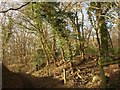
Alongside Nower Wood
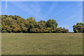
Field alongside Nower Wood.
Image: © Ian Capper
Taken: 5 Oct 2018
0.13 miles
10
Slough Farm House
Grade II listed house originally dating from the 16th Century with 16th and 20th Century extensions. See www.historicengland.org.uk/listing/the-list/list-entry/1287086.
Image: © Ian Capper
Taken: 29 Apr 2017
0.14 miles