IMAGES TAKEN NEAR TO
Langley Close, EPSOM, KT18 6HG
Introduction
This page details the photographs taken nearby to Langley Close, KT18 6HG by members of the Geograph project.
The Geograph project started in 2005 with the aim of publishing, organising and preserving representative images for every square kilometre of Great Britain, Ireland and the Isle of Man.

There are currently over 7.5m images from over14,400 individuals and you can help contribute to the project by visiting https://www.geograph.org.uk
Image Map
Images are licensed for reuse under creativecommons.org/licenses/by-sa/2.0
Notes
- Clicking on the map will re-center to the selected point.
- The higher the marker number, the further away the image location is from the centre of the postcode.
Image Listing (52 Images Found)
Images are licensed for reuse under creativecommons.org/licenses/by-sa/2.0
Image
Details
Distance
1
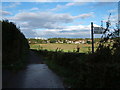
Langley Bottom
The bridleway runs parallel to Langley Vale Road. The grandstand at Epsom Race Course can be seen above the houses of Langley Vale.
Image: © Roger Miller
Taken: 1 Oct 2005
0.04 miles
2
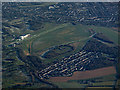
Epsom Downs racecourse from the air
Langley Vale is in the foreground, Burgh Heath beyond.
Image: © Thomas Nugent
Taken: 19 Jan 2020
0.06 miles
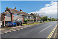
3
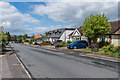
Beaconsfield Road
Housing in Langley Vale.
Image: © Ian Capper
Taken: 9 Jun 2017
0.08 miles
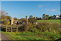
4
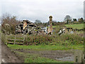
Ruin in Langley Bottom
Whatever it was seems to have been of no great age, appearing on maps round about the 1920s. Its position right at the end of a racehorse training course may be significant.
Image: © Robin Webster
Taken: 22 Nov 2010
0.09 miles
5
Ruined building
Ruined building alongside the track connecting Langley Bottom Farm with Langley Vale Road.
Image: © Ian Capper
Taken: 27 Oct 2017
0.09 miles
6
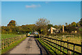
Track from Langley Bottom Farm
Track connecting Langley Bottom Farm with Langley Vale Road.
Image: © Ian Capper
Taken: 27 Oct 2017
0.09 miles
7
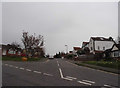
Beaconsfield Road at the junction of Grosvenor Road
Image: © David Howard
Taken: 30 Mar 2014
0.11 miles
9
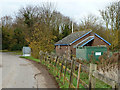
Pumping station, Langley Bottom
For a later view, after security fortification and other changes, see Image
Image: © Robin Webster
Taken: 22 Nov 2010
0.13 miles
10
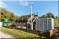
Pumping station
Thames Water pumping station in Langley Bottom, alongside Langley Vale Road.
Image: © Ian Capper
Taken: 27 Oct 2017
0.13 miles