IMAGES TAKEN NEAR TO
Yew Tree Bottom Road, EPSOM, KT18 5XT
Introduction
This page details the photographs taken nearby to Yew Tree Bottom Road, KT18 5XT by members of the Geograph project.
The Geograph project started in 2005 with the aim of publishing, organising and preserving representative images for every square kilometre of Great Britain, Ireland and the Isle of Man.

There are currently over 7.5m images from over14,400 individuals and you can help contribute to the project by visiting https://www.geograph.org.uk
Image Map
Images are licensed for reuse under creativecommons.org/licenses/by-sa/2.0
Notes
- Clicking on the map will re-center to the selected point.
- The higher the marker number, the further away the image location is from the centre of the postcode.
Image Listing (14 Images Found)
Images are licensed for reuse under creativecommons.org/licenses/by-sa/2.0
Image
Details
Distance
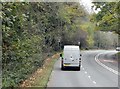
1
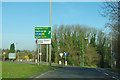
A240 - B284 turning for Epsom Downs
At the top of a hill on the main road where the 30 limit needs care - there is a speed camera at the bottom.
Image: © Robin Webster
Taken: 1 Apr 2012
0.11 miles
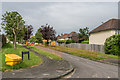
2
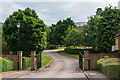
Woodlands Gardens
Gated development off North View Crescent, completed in around 2000. In the right background is part of Toyota UK's headquarters at Great Burgh.
Image: © Ian Capper
Taken: 8 Jun 2018
0.15 miles
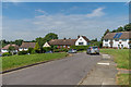
3
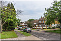
North View Crescent
c1950s housing on the line of an old footpath skirting the Great Burgh estate.
Image: © Ian Capper
Taken: 8 Jun 2018
0.17 miles
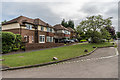
4
North View Crescent
c1950s housing on the line of an old footpath skirting the Great Burgh estate.
Image: © Ian Capper
Taken: 8 Jun 2018
0.17 miles
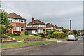
5
Colman Close
c1950s cul-de-sac off North View Crescent.
Image: © Ian Capper
Taken: 8 Jun 2018
0.19 miles
8
Sherborne Close
c1950s cul-de-sac off North View Crescent.
Image: © Ian Capper
Taken: 8 Jun 2018
0.21 miles
9
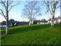
Shawley Crescent
This small green is on Shawley Crescent off Great Tattenhams.
Image: © Marathon
Taken: 4 Nov 2013
0.22 miles
10
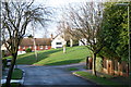
Shawley Crescent
Open space in Shawley Crescent seen from its junction with Great Tattenhams: the modern green is a remnant of the field behind Great Burgh, a manorial settlement on the Reigate Road where Home Farm Close now stands.
Image: © Hugh Craddock
Taken: 27 Dec 2013
0.22 miles