IMAGES TAKEN NEAR TO
The Spinney, EPSOM, KT18 5QX
Introduction
This page details the photographs taken nearby to The Spinney, KT18 5QX by members of the Geograph project.
The Geograph project started in 2005 with the aim of publishing, organising and preserving representative images for every square kilometre of Great Britain, Ireland and the Isle of Man.

There are currently over 7.5m images from over14,400 individuals and you can help contribute to the project by visiting https://www.geograph.org.uk
Image Map
Images are licensed for reuse under creativecommons.org/licenses/by-sa/2.0
Notes
- Clicking on the map will re-center to the selected point.
- The higher the marker number, the further away the image location is from the centre of the postcode.
Image Listing (55 Images Found)
Images are licensed for reuse under creativecommons.org/licenses/by-sa/2.0
Image
Details
Distance
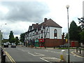
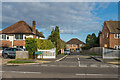
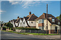
1
Great Tattenhams
c1930s housing. The road is shown without any development on the 1934 1:2,500 map but with outline development on the 1938-45 1:10,560 map.
Image: © Ian Capper
Taken: 9 Oct 2020
0.07 miles
2
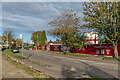
Churchill Retirement Living
Retirement apartments by Churchill Retirement Living under development on Great Tattenhams.
Image: © Ian Capper
Taken: 9 Oct 2020
0.08 miles
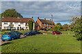
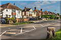
3
Burgh Heath: Merland Rise
Looking south from Great Tattenhams.
Image: © Dr Neil Clifton
Taken: 25 Nov 2014
0.10 miles
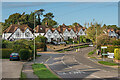
4
Straight Mile Place
Cul-de-sac off Great Tattenhams built in 2014-5.
Image: © Ian Capper
Taken: 9 Oct 2020
0.12 miles
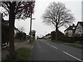
6
Emily Davison Drive, Tattenham Corner, Surrey
These excellent new houses, which were built on former railway land adjacent to the station, are ideally placed for those wishing to travel daily by rail to London. Sensitively, the road has been named Emily Davison Drive, and, if you didn't happen to know, Emily Davison was the courageous young suffragette who, in 1913, threw herself in front on the King's horse during the Derby. She died without regaining consciousness. The King's horse did not win the race.
Image: © Dr Neil Clifton
Taken: 21 Jun 2007
0.13 miles
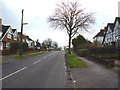
7
Downland Way
Housing in Great Burgh in an area which maps suggest was developed either immediately before or after the Second World War.
Image: © Ian Capper
Taken: 9 Oct 2020
0.14 miles
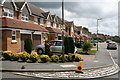
8
Merland Rise
c1930s housing. The road is first shown with some outline development on the 1938-45 1:10,560 map but does not appear on the 1934 1:2,500 map.
Image: © Ian Capper
Taken: 9 Oct 2020
0.15 miles
9
Great Tattenhams
c1930s housing. The road is shown without any development on the 1934 1:2,500 map but with outline development on the 1938-45 1:10,560 map.
Image: © Ian Capper
Taken: 9 Oct 2020
0.16 miles