IMAGES TAKEN NEAR TO
Downs Avenue, EPSOM, KT18 5HL
Introduction
This page details the photographs taken nearby to Downs Avenue, KT18 5HL by members of the Geograph project.
The Geograph project started in 2005 with the aim of publishing, organising and preserving representative images for every square kilometre of Great Britain, Ireland and the Isle of Man.

There are currently over 7.5m images from over14,400 individuals and you can help contribute to the project by visiting https://www.geograph.org.uk
Image Map
Images are licensed for reuse under creativecommons.org/licenses/by-sa/2.0
Notes
- Clicking on the map will re-center to the selected point.
- The higher the marker number, the further away the image location is from the centre of the postcode.
Image Listing (9 Images Found)
Images are licensed for reuse under creativecommons.org/licenses/by-sa/2.0
Image
Details
Distance
1
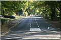
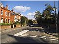
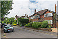
Downs Road
Downs Road, looking uphill from the mini-roundabout junction with Downs Hill Road. This broad, straight road, climbing up to the Downs, was laid out when Epsom common fields were inclosed in the second half of the nineteenth century.
Image: © Hugh Craddock
Taken: 12 Oct 2008
0.08 miles
3
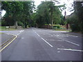
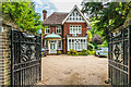
Fyfield Close
Fyfield Close was developed around 2012 in the grounds of Dame Annis house, which still stands. The C15 house formerly stood in Fyfield, Essex, but was relocated here in the 1920s. To the right of the gated entrance is a bridleway leading up to the Downs, known as Rifle Butts Alley.
Image: © Hugh Craddock
Taken: 21 Jul 2015
0.14 miles
4
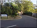
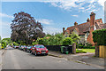
The Roseberys
Recent development (c.2007) by Mansard Homes, located between Chartwell Place and Downs Hill Road (with private access to the latter, through gate just right of photo).
Image: © Hugh Craddock
Taken: 12 Oct 2008
0.14 miles
5
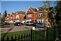
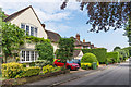
51 Burgh Heath Road
Late Victorian house in Burgh Heath Road.
Image: © Ian Capper
Taken: 8 Jun 2018
0.17 miles
6
Burgh Heath Road at the junction of Church Street
Image: © David Howard
Taken: 31 Aug 2014
0.21 miles
7
7 Lynwood Road
Early 20th Century house in Lynwood Road.
Image: © Ian Capper
Taken: 8 Jun 2018
0.22 miles
8
14 Lynwood Road
Early 20th Century house in Lynwood Road.
Image: © Ian Capper
Taken: 8 Jun 2018
0.22 miles
9
12 Lynwood Road
c1920s house in Lynwood Road.
Image: © Ian Capper
Taken: 8 Jun 2018
0.23 miles