IMAGES TAKEN NEAR TO
The Parade, EPSOM, KT18 5FE
Introduction
This page details the photographs taken nearby to The Parade, KT18 5FE by members of the Geograph project.
The Geograph project started in 2005 with the aim of publishing, organising and preserving representative images for every square kilometre of Great Britain, Ireland and the Isle of Man.

There are currently over 7.5m images from over14,400 individuals and you can help contribute to the project by visiting https://www.geograph.org.uk
Image Map
Images are licensed for reuse under creativecommons.org/licenses/by-sa/2.0
Notes
- Clicking on the map will re-center to the selected point.
- The higher the marker number, the further away the image location is from the centre of the postcode.
Image Listing (77 Images Found)
Images are licensed for reuse under creativecommons.org/licenses/by-sa/2.0
Image
Details
Distance
1
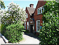
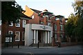
Former Magistrates' Court, Epsom
Opposite Ashley House (Image]) on Ashley Road. A pleasant Arts-and-Craft style building now awaiting a new use.
Image: © Stephen Richards
Taken: Unknown
0.03 miles
4
Lester Bowden
At the junction of Ashley Road and the High Street at Epsom
Image: © Kurseong Carl
Taken: 27 Sep 2012
0.04 miles
5
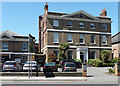
Ashley House, Epsom
A handsome mid-Georgian house, dated 1769. Of white stock brick, a standard Georgian composition of two-and-a-half-storeys and five bays, with the central three bays projecting slightly and surmounted by a pediment. The floors are articulated by plat bands. A fine doorcase with "composite Tower of the Winds and Ionic columns and back pilasters". Grade II* listed.
For a time I think this was Epsom and Ewell's registry office, but it is now used as offices.
Image: © Stephen Richards
Taken: Unknown
0.05 miles
6
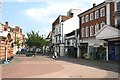
Epsom - High Street
Palatial architecture and Lloyds Bank in the centre of Epsom.
Image: © Colin Smith
Taken: 23 Dec 2015
0.06 miles
7
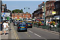
High Street, Epsom
The floral displays brighten this up enormously.
Image: © Bill Boaden
Taken: 1 Aug 2011
0.06 miles
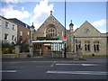
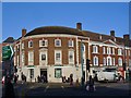
9
Town Hall, The Parade
The town hall for Epsom and Ewell Borough Council, tucked away in The Parade behind the High Street.
Image: © Hugh Craddock
Taken: 15 Jul 2008
0.07 miles
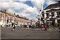
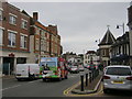
10
High Street from the Clock Tower
Looking east along the High Street, with the base of the Clock Tower visible on the left, and the entrance to Boots on the right. Just ahead, below the tree, is a drinking trough provided by the Metropolitan Drinking Fountain and Cattle Trough Association. The white sided building on the right, projecting slightly (and now the Nationwide Building Society), and to its right, the much smaller Nell Gwynne House, are the only historic buildings on the right hand side of the High Street visible here and in this Francis Frith photo dating from 1924: http://www.francisfrith.com/epsom/photos/high-street-1924_75371a/ and http://www.geograph.org.uk/stuff/frith.php?id=2361498 . On the left side of the road can be seen a three-storey building which now houses (among others) the post office. There is now no sign of the King's Head, which was on the site now occupied by Boots.
Image: © Hugh Craddock
Taken: 17 Apr 2011
0.08 miles