IMAGES TAKEN NEAR TO
Upper High Street, EPSOM, KT17 4RQ
Introduction
This page details the photographs taken nearby to Upper High Street, KT17 4RQ by members of the Geograph project.
The Geograph project started in 2005 with the aim of publishing, organising and preserving representative images for every square kilometre of Great Britain, Ireland and the Isle of Man.

There are currently over 7.5m images from over14,400 individuals and you can help contribute to the project by visiting https://www.geograph.org.uk
Image Map
Images are licensed for reuse under creativecommons.org/licenses/by-sa/2.0
Notes
- Clicking on the map will re-center to the selected point.
- The higher the marker number, the further away the image location is from the centre of the postcode.
Image Listing (33 Images Found)
Images are licensed for reuse under creativecommons.org/licenses/by-sa/2.0
Image
Details
Distance
1
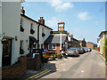
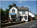
Epsom: The 'Barley Mow'
Another attractive Epsom pub with everything you are likely to need.
Image: © Dr Neil Clifton
Taken: 21 Jul 2013
0.04 miles
3
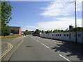
Church Road, Epsom
Church Road leads up and over the railway line between Epsom and Ewell East. The bridge can be seen at the top of the rise. The houses on the left are in Beaconsfield Place.
Image: © Marathon
Taken: 14 May 2014
0.08 miles
5
Epsom: The 'Railway Guard'
This attractive pub is situated on Church Road
Image: © Dr Neil Clifton
Taken: 21 Jul 2013
0.09 miles
6
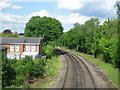
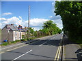
Looking along the railway line towards Ewell East
The Croydon & Epsom Railway was opened in 1847 and the Croydon & Epsom was soon taken over by the London, Brighton & South Coast Railway. This view looks from the bridge carrying Church Road over the line towards Ewell East, Cheam and Sutton. The houses to the left are in Beaconsfield Place.
Image: © Marathon
Taken: 14 May 2014
0.11 miles
7
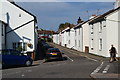
Providence Place, Epsom
A quiet back street off Church Road.
Image: © Bill Boaden
Taken: 1 Aug 2011
0.13 miles
8
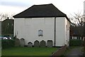
Bugby chapel and burial ground, Prospect Place
Side view of a former Calvinist chapel, built around 1780, by William Bugby, and later used as a Salem Baptist chapel and more recently as a synagogue. Now converted for office use. Grade II listed. To the east, in the foreground, is the burial ground, with a number of headstones laid against the east wall of the chapel. http://en.wikipedia.org/wiki/Bugby_Chapel
Image: © Hugh Craddock
Taken: 18 Feb 2014
0.14 miles
9
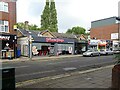
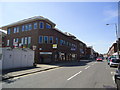
Epsom Town railway station (site), Surrey
Opened as "Epsom" in 1847 by the London Brighton and South Coast Railway on what is today the line from Croydon to Leatherhead, this station closed in 1929 when the current Epsom railway station was rebuilt to take the extra traffic. The 1847 station became "Epsom Town" from 1870 to c.1900, and again from 1923 until closure.
View north at the former forecourt. The building is still there, behind the modern shop frontages. And behind the building, the railway line still runs.
Image: © Nigel Thompson
Taken: 29 Sep 2020
0.15 miles
10
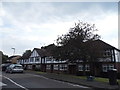
Mock Tudor terrace on Bridge Road, Epsom
Image: © David Howard
Taken: 1 Jun 2014
0.15 miles