IMAGES TAKEN NEAR TO
Delaporte Close, EPSOM, KT17 4AF
Introduction
This page details the photographs taken nearby to Delaporte Close, KT17 4AF by members of the Geograph project.
The Geograph project started in 2005 with the aim of publishing, organising and preserving representative images for every square kilometre of Great Britain, Ireland and the Isle of Man.

There are currently over 7.5m images from over14,400 individuals and you can help contribute to the project by visiting https://www.geograph.org.uk
Image Map
Images are licensed for reuse under creativecommons.org/licenses/by-sa/2.0
Notes
- Clicking on the map will re-center to the selected point.
- The higher the marker number, the further away the image location is from the centre of the postcode.
Image Listing (32 Images Found)
Images are licensed for reuse under creativecommons.org/licenses/by-sa/2.0
Image
Details
Distance
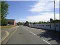
1
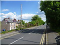
Church Road, Epsom
Church Road leads up and over the railway line between Epsom and Ewell East. The bridge can be seen at the top of the rise. The houses on the left are in Beaconsfield Place.
Image: © Marathon
Taken: 14 May 2014
0.03 miles
2
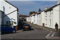
Providence Place, Epsom
A quiet back street off Church Road.
Image: © Bill Boaden
Taken: 1 Aug 2011
0.05 miles
3
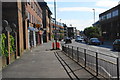
East Street, Epsom
This is the A24 north of Epsom town centre.
Image: © Bill Boaden
Taken: 1 Aug 2011
0.07 miles
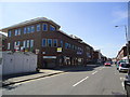
4
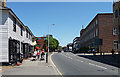
East Street, Epsom
The A24 just north of Epsom town centre. This stretch is mostly lined with medium-sized C20th office blocks, but on the left can be seen a pair of pretty weatherboarded cottages.
Image: © Stephen Richards
Taken: Unknown
0.09 miles
5
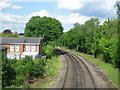
Looking along the railway line towards Ewell East
The Croydon & Epsom Railway was opened in 1847 and the Croydon & Epsom was soon taken over by the London, Brighton & South Coast Railway. This view looks from the bridge carrying Church Road over the line towards Ewell East, Cheam and Sutton. The houses to the left are in Beaconsfield Place.
Image: © Marathon
Taken: 14 May 2014
0.09 miles
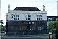
9
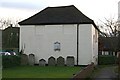
Bugby chapel and burial ground, Prospect Place
Side view of a former Calvinist chapel, built around 1780, by William Bugby, and later used as a Salem Baptist chapel and more recently as a synagogue. Now converted for office use. Grade II listed. To the east, in the foreground, is the burial ground, with a number of headstones laid against the east wall of the chapel. http://en.wikipedia.org/wiki/Bugby_Chapel
Image: © Hugh Craddock
Taken: 18 Feb 2014
0.11 miles
10
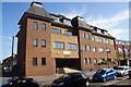
Saddlers Court, Epsom
An office block on East Street.
Image: © Bill Boaden
Taken: 1 Aug 2011
0.12 miles