IMAGES TAKEN NEAR TO
Richlands Avenue, EPSOM, KT17 2JW
Introduction
This page details the photographs taken nearby to Richlands Avenue, KT17 2JW by members of the Geograph project.
The Geograph project started in 2005 with the aim of publishing, organising and preserving representative images for every square kilometre of Great Britain, Ireland and the Isle of Man.

There are currently over 7.5m images from over14,400 individuals and you can help contribute to the project by visiting https://www.geograph.org.uk
Image Map
Images are licensed for reuse under creativecommons.org/licenses/by-sa/2.0
Notes
- Clicking on the map will re-center to the selected point.
- The higher the marker number, the further away the image location is from the centre of the postcode.
Image Listing (5 Images Found)
Images are licensed for reuse under creativecommons.org/licenses/by-sa/2.0
Image
Details
Distance
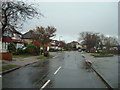
2
Rosedale Road, Stoneleigh
Typical of thousands of streets in these Surrey suburbs - 1930s residential development, mostly 'semis'. The view is NNE from Stoneleigh Broadway, and the road runs through to Central Road, Worcester Park.
Local railway history is worth considering. Dipping into Dendy Marshall's 'History of the Southern Railway', I found that the Wimbledon to Epsom railway line was constructed through here as early as 1859. But no station was provided at Stoneleigh (which in any case was simply farmland), so for 73 years trains stopped at Worcester Park (north) then ran through to Ewell West (south).
The station at Stoneleigh opened in 1932, and - simply from looking at the 'urban fabric' - it is clear that a torrent of 'dormitory' development then followed. While the coming of the railway must have been the critical factor, it was not the only one: the early 1930s were the heyday of the Austin 7 and Morris 8 - so that, for the first time, car-ownership came within reach for families of modest means.
Image: © Stefan Czapski
Taken: 1 Dec 2017
0.21 miles
3
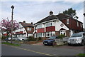
Woodstone Avenue
These 1930's semi detached houses have been considerably extended to result in large houses. As 3 bedroom houses they can sell for up to £500,000 but as five bedroom extended properties they are currently selling for about £600,000 (April 2015)
Image: © Nigel Mykura
Taken: 17 Apr 2015
0.22 miles
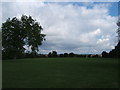
4
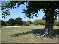
Old oak in Cuddington Recreation Ground
The name Cuddington almost vanished from the map when the medieval village, parish church and manor house were ruthlessly destroyed in 1538 to provide the site for Henry VIIIth to build his palace and home park at Nonsuch. The parish, which covers the area between Ewell and Cheam, including Nonsuch Park is still called Cuddington.
Cuddington Recreation Ground was once the fields and woods of Sparrow Farm, which still occupied the area early in the 20th century. The farmstead was situated towards the south-east end of the present-day park. Sparrow farm Road to the south of the park commemorates the name. This old oak tree, like some of the others, is probably a survivor from Avenue Wood, which is marked on maps from the early 20th century in the area to the north of the farm.
The infant Beverley Brook can be found within the trees on the left. The Wembley Arch is also visible from here.
Image: © Marathon
Taken: 21 Aug 2013
0.24 miles