IMAGES TAKEN NEAR TO
West Street, EPSOM, KT17 1XB
Introduction
This page details the photographs taken nearby to West Street, KT17 1XB by members of the Geograph project.
The Geograph project started in 2005 with the aim of publishing, organising and preserving representative images for every square kilometre of Great Britain, Ireland and the Isle of Man.

There are currently over 7.5m images from over14,400 individuals and you can help contribute to the project by visiting https://www.geograph.org.uk
Image Map
Images are licensed for reuse under creativecommons.org/licenses/by-sa/2.0
Notes
- Clicking on the map will re-center to the selected point.
- The higher the marker number, the further away the image location is from the centre of the postcode.
Image Listing (151 Images Found)
Images are licensed for reuse under creativecommons.org/licenses/by-sa/2.0
Image
Details
Distance
1
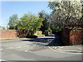
Lyncroft Gardens, Ewell, Surrey
Looking down Lyncroft Gardens from the corner of the junction with Spring Street.
Image: © Christine Matthews
Taken: 22 Apr 2010
0.06 miles
2
Lyncroft Gardens, Ewell, Surrey
Lyncroft Gardens near the junction with Spring Street.
Image: © Christine Matthews
Taken: 22 Apr 2010
0.08 miles
3
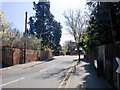
Spring Street, Ewell, Surrey
Looking along Spring Street from the corner of Lyncroft Gardens.
Image: © Christine Matthews
Taken: 22 Apr 2010
0.11 miles
4
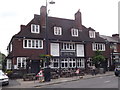
Green Man, Ewell
Large public house and restaurant on Ewell's High Street. It was rebuilt in the 1930s.
www.epsomandewellhistoryexplorer.org.uk
Image: © Colin Smith
Taken: 17 Jul 2012
0.11 miles
5

Flower Bed, Bourne Hall
Summer colour at Ewell's Bourne Hall (1970), a local library, museum and social venue.
www.epsomandewellhistoryexplorer.org.uk
Image: © Colin Smith
Taken: 17 Jul 2012
0.12 miles
6
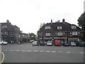
High Street Ewell from the junction of Reigate Road
Image: © David Howard
Taken: 1 Jun 2014
0.12 miles
7
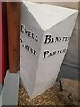
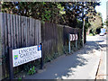
Old Boundary Marker in Bourne Hall Museum, Ewell
Parish Boundary Marker on display in Bourne Hall Museum, Spring Street, Ewell KT17 1UF.
Milestone Society National ID: SY_EWEBAN01pb
Image: © W Cosgrave
Taken: 1 Aug 2023
0.12 miles
8
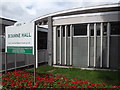
Bourne Hall
Entrance area to the circular Bourne Hall (1970), Ewell's local library, museum and social venue.
www.epsomandewellhistoryexplorer.org.uk
Image: © Colin Smith
Taken: 17 Jul 2012
0.12 miles
9
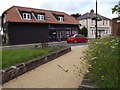
Ewell High Street
Small park and an old black weatherboarded barn which now contains an estate agent's business.
www.epsomandewellhistoryexplorer.org.uk
Image: © Colin Smith
Taken: 17 Jul 2012
0.13 miles
10

Ewell
The junction of High Street and Reigate Road.
Image: © Peter Trimming
Taken: 4 Mar 2020
0.13 miles