IMAGES TAKEN NEAR TO
Guildford Road, CHERTSEY, KT16 0QN
Introduction
This page details the photographs taken nearby to Guildford Road, KT16 0QN by members of the Geograph project.
The Geograph project started in 2005 with the aim of publishing, organising and preserving representative images for every square kilometre of Great Britain, Ireland and the Isle of Man.

There are currently over 7.5m images from over14,400 individuals and you can help contribute to the project by visiting https://www.geograph.org.uk
Image Map
Images are licensed for reuse under creativecommons.org/licenses/by-sa/2.0
Notes
- Clicking on the map will re-center to the selected point.
- The higher the marker number, the further away the image location is from the centre of the postcode.
Image Listing (15 Images Found)
Images are licensed for reuse under creativecommons.org/licenses/by-sa/2.0
Image
Details
Distance
1
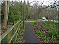
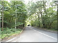
Walkway beside the A320
The walkway and cycle path alongside the A320. The access road to Bramshill Manor cuts across the walkway. The A320 on the right is closed off by the van just north of the Brox Road junction for drainage work to be undertaken.
Image: © Alan Hunt
Taken: 8 Apr 2014
0.07 miles
2
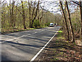
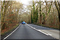
The A320, Guildford Road
Looking south along the A320 towards the Brox Road junction. The vans mark the closure point on the road for drainage work.
Image: © Alan Hunt
Taken: 9 Apr 2014
0.07 miles
3
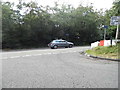
Brox Road at the junction of Guildford Road
Image: © David Howard
Taken: 17 Aug 2014
0.07 miles
4
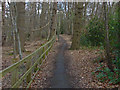
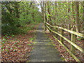
Walkway along the A320
The walkway and cycle path that runs along this part of the A320. Sandpit Plantation is on the left, the A320 is about 30 feet to the right.
Image: © Alan Hunt
Taken: 8 Apr 2014
0.08 miles
5
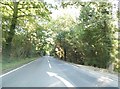
A320 Guildford Road heading north
Towards Chertsey.
Image: © Robin Webster
Taken: 8 Dec 2019
0.10 miles
7
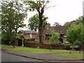
Brox Road, north of Woking
Houses on the south side of Brox Road, by Greatwood Close
Image: © David Hawgood
Taken: 17 May 2006
0.15 miles
8
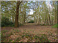
Sandpit Plantation
The woodland that borders the A320 between Ottershaw and Woking.
Image: © Alan Hunt
Taken: 8 Apr 2014
0.17 miles
10
Walkway and cycle path
The combined walkway and cycle path that runs alongside the A320 from Colebrooke Place to Wey Farm.
Image: © Alan Hunt
Taken: 8 Apr 2014
0.21 miles