IMAGES TAKEN NEAR TO
Mawbey Road, CHERTSEY, KT16 0HB
Introduction
This page details the photographs taken nearby to Mawbey Road, KT16 0HB by members of the Geograph project.
The Geograph project started in 2005 with the aim of publishing, organising and preserving representative images for every square kilometre of Great Britain, Ireland and the Isle of Man.

There are currently over 7.5m images from over14,400 individuals and you can help contribute to the project by visiting https://www.geograph.org.uk
Image Map
Images are licensed for reuse under creativecommons.org/licenses/by-sa/2.0
Notes
- Clicking on the map will re-center to the selected point.
- The higher the marker number, the further away the image location is from the centre of the postcode.
Image Listing (44 Images Found)
Images are licensed for reuse under creativecommons.org/licenses/by-sa/2.0
Image
Details
Distance
3
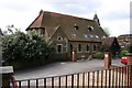
Ottershaw
Off the B3121 in the north of the square, this appeared to be a church - and is marked as such on the OS map. However, it turned out to be a private residence, nicely converted(!)
Image: © Brendan and Ruth McCartney
Taken: 8 May 2005
0.05 miles
4
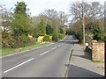
Murray Road, Ottershaw
Looking east along Murray Road between Ottershaw and Addlestone.
Image: © Alan Hunt
Taken: 10 Apr 2015
0.08 miles
5
Ottershaw Social Club, 19 Brox Road
The club was originally started as Ottershaw Working Men's Club in 1883. It was for almost 80 years a men only club, but in 1962 women were admitted, although they were not allowed to become full members until the late 1980's. Today it is a family orientated village club, with a wide age range of members. There is a bar and also food is served, but not on every day of the week. During its history the club has also amalgamated with the local British Legion Club.
Image: © P L Chadwick
Taken: 12 Aug 2010
0.10 miles
6
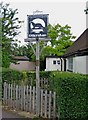
Ottershaw village sign
The sign is by Brook Hall, which is the village hall. For the background to the sign, see: Image
Image: © P L Chadwick
Taken: 12 Aug 2010
0.12 miles
7
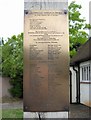
Plaque on village sign
The Ottershaw Society commissioned the sign to celebrate the Millennium Anniversary. This plaque is on the sign's post. For more details of the plaque, please select the maximum resolution version of this image.
The sign:- Image
Image: © P L Chadwick
Taken: 12 Aug 2010
0.12 miles
8
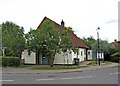
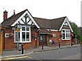
Brook Hall (village hall), Brox Road
The original Brook Hall, was a church hall, donated to the Parochial Church Council by Eliza Brook, the widow of the Rev. Arthur Brook, in his memory. It was destroyed by fire in the Second World War, when it was ironically being used as a temporary fire station. Shortly after the war, the present hall was erected. In 2008 it was leased by the PCC as a village hall, to a new charitable organisation, who are running it on behalf of the local community. They are presently undertaking fundraising to make improvements to the building.
Image: © P L Chadwick
Taken: 12 Aug 2010
0.12 miles
9
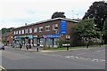
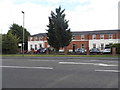
Block of modern shops, corner of Brox Road and Shaw Close
These shops front Brox Road, and include Ottershaw Dental Practice, Shawmore Estate Agents, Clikkers Hairdressers, Lloyds Pharmacy, a Londis store, and Coopers News.
Image: © P L Chadwick
Taken: 12 Aug 2010
0.12 miles
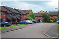
10
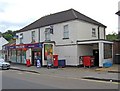
One-Stop shop & Post Office, 18-20 Brox Road
As well as being a One-Stop convenience store, this is also the local post office.
Image: © P L Chadwick
Taken: 12 Aug 2010
0.12 miles