IMAGES TAKEN NEAR TO
Addlestone Moor, ADDLESTONE, KT15 2QF
Introduction
This page details the photographs taken nearby to Addlestone Moor, KT15 2QF by members of the Geograph project.
The Geograph project started in 2005 with the aim of publishing, organising and preserving representative images for every square kilometre of Great Britain, Ireland and the Isle of Man.

There are currently over 7.5m images from over14,400 individuals and you can help contribute to the project by visiting https://www.geograph.org.uk
Image Map
Images are licensed for reuse under creativecommons.org/licenses/by-sa/2.0
Notes
- Clicking on the map will re-center to the selected point.
- The higher the marker number, the further away the image location is from the centre of the postcode.
Image Listing (15 Images Found)
Images are licensed for reuse under creativecommons.org/licenses/by-sa/2.0
Image
Details
Distance
1
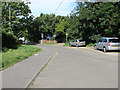
Addlestone Moor
The short spur road off Addlestone Moor with the entrance to the Philip Southcote schoolon the right and the footpath to Chertsey Meads on the left.
Image: © Alan Hunt
Taken: 17 Aug 2012
0.06 miles
2
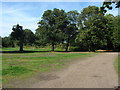
Access land, Woburn Park
An area of access land south of the River Bourne adjacent to Woburn Park Farm. Part of it is taken up by a BMX cycle park
Image: © Alan Hunt
Taken: 17 Aug 2012
0.07 miles
3
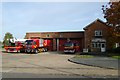
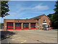
Chertsey fire station
Chertsey fire station, Addlestone Moor, Addlestone, Surrey, with some of its appliances
Image: © Kevin Hale
Taken: 12 Nov 2006
0.08 miles
4
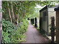
National cycle network south of Chertsey Bridge
A narrow footpath (not a bridleway!) between Mead Lane and Addlestone Moor.
Image: © David Lally
Taken: 7 Jun 2024
0.09 miles
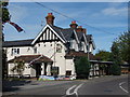
5
Chertsey Fire Station
The fire station on Addlestone Moor, A short road that leads off the roundabout at the end of St Peter's Way.
Image: © Alan Hunt
Taken: 17 Aug 2012
0.10 miles
6
Chertsey Fire Station
Cycling past I thought that surely "Kevin Hale was here" I was right: Image Since then it's been geographed one more time Image
Image: © David Lally
Taken: 9 Jun 2024
0.10 miles
7
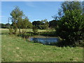
Pond. Chertsey Meads
A small pond, not even marked on the large scale maps but clearly visible on aerial photographs near the southern edge of the Meads.
Image: © Alan Hunt
Taken: 17 Aug 2012
0.12 miles
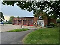
8
The Woburn Arms
A public house on Addlestone Moor, A short road that comes off the roundabout at the bottom of Woburn Hill.
Image: © Alan Hunt
Taken: 17 Aug 2012
0.15 miles
9
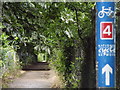
National Cycle Network 4
Sign on a footpath passing the Fordwater Trading Estate at Chertsey.
Image: © Colin Smith
Taken: 16 Jul 2012
0.16 miles
10
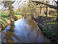
The Bourne, Chertsey
Along the south side of Chertsey Meads on its way to the Thames.
Image: © Robin Webster
Taken: 16 Mar 2020
0.16 miles