IMAGES TAKEN NEAR TO
Alexandra Road, ADDLESTONE, KT15 2PF
Introduction
This page details the photographs taken nearby to Alexandra Road, KT15 2PF by members of the Geograph project.
The Geograph project started in 2005 with the aim of publishing, organising and preserving representative images for every square kilometre of Great Britain, Ireland and the Isle of Man.

There are currently over 7.5m images from over14,400 individuals and you can help contribute to the project by visiting https://www.geograph.org.uk
Image Map (60 Images)


Getting Data...Please wait
Leaflet Map data © OpenStreetMap
Images are licensed for reuse under creativecommons.org/licenses/by-sa/2.0
Notes
- Clicking on the map will re-center to the selected point.
- The higher the marker number, the further away the image location is from the centre of the postcode.
Image Listing (60 Images Found)
Images are licensed for reuse under creativecommons.org/licenses/by-sa/2.0
Image
Details
Distance
1

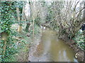
The Bourne
The Bourne viewed from Alexandra Road, Addlestone.
Image: © Ajay Tegala
Taken: 20 Sep 2008
0.04 miles
2
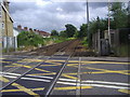
Railway line leaving Addlestone station
The line leaving the station beyond the level crossing
Image: © David Howard
Taken: 29 Jun 2008
0.13 miles
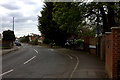
3
Junction of Bourneside Road and Bois Hall Road, Addlestone
Image: © Robert Eva
Taken: 21 Apr 2017
0.13 miles
4
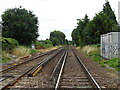
Railway heading south from Addlestone Railway Station
From the Level crossing on Station Road (B3121).
Image: © JThomas
Taken: 25 Jul 2022
0.14 miles
5
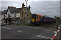
Addlestone level crossing
A South West trains 450 unit leaves for Weybridge
Image: © Robert Eva
Taken: 21 Apr 2017
0.14 miles

7
The Bourne, Addlestone
From the bridge by Albert Road
Image: © David Howard
Taken: 11 Mar 2013
0.15 miles
9
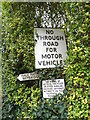
Three old signs at the end of Albert Road, Addlestone
This is a closer view of the set added just before I took these, no through road is pre-Worboys, the footpath arrow is a fingerpost, which were separate from the system stopped in 1964 and still being used nationally, and what is probably an old council made prohibition sign as on a footpath rather than a road.
Image: © David Howard
Taken: 11 Mar 2013
0.16 miles
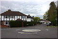
10
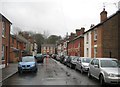
Addlestone: Albert Road
This attractive cul-de-sac was originlly developed in the 1880s with later infills. The original Victorian houses have kept their "Villa" names. The modern block on the left was once the site of an Infants' School.
Image: © Nigel Cox
Taken: 10 Feb 2013
0.16 miles