IMAGES TAKEN NEAR TO
Brighton Road, ADDLESTONE, KT15 1PX
Introduction
This page details the photographs taken nearby to Brighton Road, KT15 1PX by members of the Geograph project.
The Geograph project started in 2005 with the aim of publishing, organising and preserving representative images for every square kilometre of Great Britain, Ireland and the Isle of Man.

There are currently over 7.5m images from over14,400 individuals and you can help contribute to the project by visiting https://www.geograph.org.uk
Image Map
Images are licensed for reuse under creativecommons.org/licenses/by-sa/2.0
Notes
- Clicking on the map will re-center to the selected point.
- The higher the marker number, the further away the image location is from the centre of the postcode.
Image Listing (13 Images Found)
Images are licensed for reuse under creativecommons.org/licenses/by-sa/2.0
Image
Details
Distance
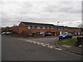
2
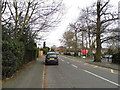
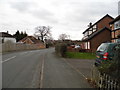
Liberty Lane
The eastern end of Liberty Lane with the junction with Parklands in the foreground.
Image: © Alan Hunt
Taken: 28 Aug 2012
0.04 miles
3
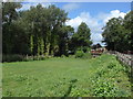
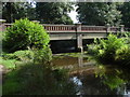
Crockford Bridge
The bridge that carries the A318, New Haw Road over the River Bourne just to the south of Addlestone.
Image: © Alan Hunt
Taken: 28 Aug 2012
0.06 miles
4
Crockford Bridge
The Crockford Bridge over the River Bourne just to the south of Addlestone.
Image: © Alan Hunt
Taken: 28 Aug 2012
0.06 miles
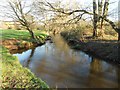
5
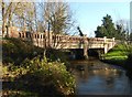
Addlestone Bourne: Crockford Bridge
This is the upstream side of the bridge that takes the A318 New Haw Road over the river. Victorian Ordnance Survey maps show that there was a ford where the current bridge is, with the old Crockford Bridge a slight distance downstream.
Image: © Nigel Cox
Taken: 15 Jan 2016
0.07 miles
6
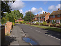
Liberty Lane
A view of the eastern end of Liberty Lane, a residential road in Addlestone.
Image: © Alan Hunt
Taken: 28 Aug 2012
0.09 miles
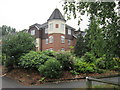
9
Addlestone Bourne: Next to Sayes Court Open Space
This is the view looking downstream next to Sayes Court Open Space. The river is beginning to seriously erode the bank on the left here. The original Sayes Court house, which was at the top of the hill to the left, was demolished in 1928.
Image: © Nigel Cox
Taken: 15 Jan 2016
0.19 miles