IMAGES TAKEN NEAR TO
Church Grove, KINGSTON UPON THAMES, KT1 4ET
Introduction
This page details the photographs taken nearby to Church Grove, KT1 4ET by members of the Geograph project.
The Geograph project started in 2005 with the aim of publishing, organising and preserving representative images for every square kilometre of Great Britain, Ireland and the Isle of Man.

There are currently over 7.5m images from over14,400 individuals and you can help contribute to the project by visiting https://www.geograph.org.uk
Image Map
Images are licensed for reuse under creativecommons.org/licenses/by-sa/2.0
Notes
- Clicking on the map will re-center to the selected point.
- The higher the marker number, the further away the image location is from the centre of the postcode.
Image Listing (295 Images Found)
Images are licensed for reuse under creativecommons.org/licenses/by-sa/2.0
Image
Details
Distance
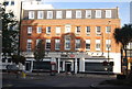
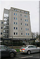
2
Kingston Bridge House
Part of Kingston University.
Image: © N Chadwick
Taken: 7 Oct 2012
0.01 miles
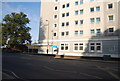
3
Kingston Bridge House
Halls of residence, converted from offices.
Image: © Hugh Venables
Taken: 27 Dec 2015
0.01 miles
6
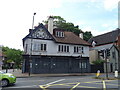
The Old Kings Head, Hampton Wick
On Hampton Court Road.
See Image] for sign.
Image: © JThomas
Taken: 27 May 2022
0.02 miles
7
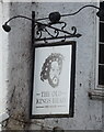
Sign for the Old Kings Head, Hampton Wick
See Image] for context.
Image: © JThomas
Taken: 27 May 2022
0.02 miles