IMAGES TAKEN NEAR TO
Grove Crescent, KINGSTON UPON THAMES, KT1 2EU
Introduction
This page details the photographs taken nearby to Grove Crescent, KT1 2EU by members of the Geograph project.
The Geograph project started in 2005 with the aim of publishing, organising and preserving representative images for every square kilometre of Great Britain, Ireland and the Isle of Man.

There are currently over 7.5m images from over14,400 individuals and you can help contribute to the project by visiting https://www.geograph.org.uk
Image Map (Loading...)


Getting Data...Please wait
Leaflet Map data © OpenStreetMap
Images are licensed for reuse under creativecommons.org/licenses/by-sa/2.0
Notes
- Clicking on the map will re-center to the selected point.
- The higher the marker number, the further away the image location is from the centre of the postcode.
Image Listing (103 Images Found)
Images are licensed for reuse under creativecommons.org/licenses/by-sa/2.0
Image
Details
Distance
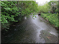
2
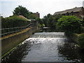
Hogsmill River
Looking upstream towards Knights Park Bridge. Very shallow angle weir.
Image: © Hugh Venables
Taken: 8 Apr 2006
0.06 miles
3
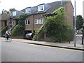
Flood-tolerant houses, Kingston upon Thames
These are in Denmark Road. They are quite different to the adjacent property with the living area clearly raised above anticipated flood level.
Image: © Julian Smith
Taken: 30 Jun 2006
0.06 miles
4
Hogsmill River
From Knights Park bridge.
Image: © Hugh Venables
Taken: 13 Apr 2017
0.08 miles
5
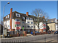
Springfield Court
A private apartment block on Springfield Road. It looks to be of 1920s or 1930s era.
Image: © Stephen Craven
Taken: 8 Mar 2012
0.09 miles
6
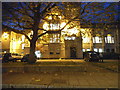
County Hall, Kingston
Besides not officially being in the county of Surrey since 1965 (except postally as it cost too much to change the codes) the main administrative centre remains in Kingston.
Image: © David Howard
Taken: 17 Nov 2014
0.10 miles
7
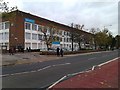
Kingston University Penrhyn Road Campus
Image: © David Martin
Taken: 26 Oct 2012
0.10 miles
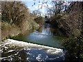
9
River Hogsmill Gauging Weir, Kingston upon Thames
Looking upstream from footbridge.
Image: © Julian Smith
Taken: 30 Jun 2006
0.10 miles
10
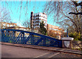
Bridge, Badge and University
Knights Park Bridge was built in 1892. These days it's closed to vehicles.
You can see the three fish insignia of the old Royal Borough of Kingston on the wall. This dates back to at least 1481 when the borough was incorporated during Edward 4th's reign. The fish are salmon, from three fisheries that were recorded here in the Domesday Book. http://www.kingston.gov.uk/browse/leisure/museum/kingston_history/kingstons_royal_connections/borough_seal_rc.htm
Kingston is now a London Borough and the logo is slightly different.
In the background is Kingston University.
Kingston facts on http://en.wikipedia.org/wiki/Royal_Borough_of_Kingston_upon_Thames
Image: © Des Blenkinsopp
Taken: 12 Dec 2011
0.10 miles