IMAGES TAKEN NEAR TO
Ellesmere Place, WALTON-ON-THAMES, KT12 5AE
Introduction
This page details the photographs taken nearby to Ellesmere Place, KT12 5AE by members of the Geograph project.
The Geograph project started in 2005 with the aim of publishing, organising and preserving representative images for every square kilometre of Great Britain, Ireland and the Isle of Man.

There are currently over 7.5m images from over14,400 individuals and you can help contribute to the project by visiting https://www.geograph.org.uk
Image Map
Images are licensed for reuse under creativecommons.org/licenses/by-sa/2.0
Notes
- Clicking on the map will re-center to the selected point.
- The higher the marker number, the further away the image location is from the centre of the postcode.
Image Listing (10 Images Found)
Images are licensed for reuse under creativecommons.org/licenses/by-sa/2.0
Image
Details
Distance
3
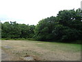
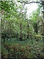
Grassland and woodland off Queens Road (A317)
Image: © JThomas
Taken: 25 Jul 2022
0.12 miles
4
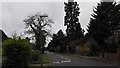
Oatlands Avenue
Mature Wellingtonia tree - Sequoiadendron giganteum, indicating an older house.
https://en.wikipedia.org/wiki/Sequoiadendron_giganteum
Image: © James Emmans
Taken: 6 Nov 2015
0.17 miles
5
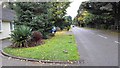
Oatlands Avenue
The road runs parallel to the railway. Must have been built on the original Ashley Park estate after the land was sold to the railway company, the railway was built in 1838 cutting through Ashley Park. The road could have been built later around 1880.
Image: © James Emmans
Taken: 6 Nov 2015
0.22 miles
6
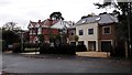
The Old and The New
St Mary's Road Weybridge. The new semi-detached homes are replacing a Victorian house.
Image: © James Emmans
Taken: 6 Nov 2015
0.23 miles
7
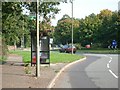
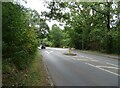
Bus stop on the north side of Queens Road
looking east
Image: © Andrew Longton
Taken: 11 Oct 2005
0.23 miles
8
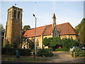
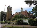
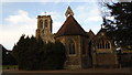
Weybridge: St Mary's Church, Oatlands Park
This Grade II Listed church, with its three stage tower and separate bell tower on the roof, was built of rubblestone in 1862. The Ordnance Survey map of 1868 shows it in isolated wooded seclusion with only a couple of large houses nearby. The Church's website is here http://www.stmaryoatlands.org.uk/welcome.htm
Image: © Nigel Cox
Taken: 23 Oct 2011
0.24 miles