IMAGES TAKEN NEAR TO
Lansdown Close, WALTON-ON-THAMES, KT12 3NN
Introduction
This page details the photographs taken nearby to Lansdown Close, KT12 3NN by members of the Geograph project.
The Geograph project started in 2005 with the aim of publishing, organising and preserving representative images for every square kilometre of Great Britain, Ireland and the Isle of Man.

There are currently over 7.5m images from over14,400 individuals and you can help contribute to the project by visiting https://www.geograph.org.uk
Image Map
Images are licensed for reuse under creativecommons.org/licenses/by-sa/2.0
Notes
- Clicking on the map will re-center to the selected point.
- The higher the marker number, the further away the image location is from the centre of the postcode.
Image Listing (10 Images Found)
Images are licensed for reuse under creativecommons.org/licenses/by-sa/2.0
Image
Details
Distance
1
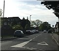
Ambleside Avenue, Walton-on-Thames
Mini-roundabout on Ambleside Avenue.
Image: © Daniel Parks
Taken: 3 May 2018
0.07 miles
2
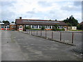
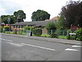
Walton-on-Thames: Former Swansmere Infants School
Photographed for the record this is the former Swansmere Infants School, now in a derelict state after closure around 2004, when the school amalgamated with Ambleside Junior School to form the new Walton Oak Primary School. The closure appears to have become necessary as both Swansmere and Ambleside were suffering from undersubscribed numbers of children.
Image: © Nigel Cox
Taken: 13 Aug 2008
0.10 miles
3
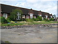
Walton-on-Thames: Former Ambleside Junior School (2)
Please see Image for details.
Image: © Nigel Cox
Taken: 13 Aug 2008
0.15 miles
4
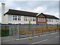
Walton-on-Thames: Former Ambleside Junior School (1)
Photographed for the record this is the former Ambleside Junior School, now in a disused state after closure around 2004, when the school amalgamated with Swansmere Infants School to form the new Walton Oak Primary School. The closure appears to have become necessary as both Swansmere and Ambleside were suffering from undersubscribed numbers of children. The access road to the new school is in the foreground. Ambleside Junior School dates from the 1920s or early 1930s.
Image: © Nigel Cox
Taken: 13 Aug 2008
0.18 miles
5
Walton-on-Thames: St John's Church
St John's Church is in the Parish of Walton-on-Thames and was built in the Furrows in 1953 to serve the community in the south and east of the parish. Its page on the Parish website is here http://www.waltonparish.org.uk/St_Johns.html
Image: © Nigel Cox
Taken: 13 Aug 2008
0.21 miles
6
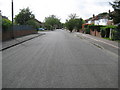
Walton-on-Thames: The Furrows
The broad expanse of an estate road in the Rydens area of Walton-on-Thames, probably named after its former agricultural use. The Ordnance Survey map of 1938 shows the road layout and names but the 1919 edition shows only the original field layout.
Image: © Nigel Cox
Taken: 13 Aug 2008
0.22 miles
7
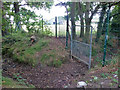
Dry ditch by Cottimore Lane
Beyond the fence are fields of Walton Oak School.
Image: © Robin Webster
Taken: 1 Sep 2012
0.22 miles
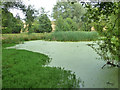
9
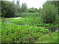
Walton-on-Thames: Shaw Drive or Fishmore Farm pond
This pond is obviously well-managed with a great variety of water-loving plants and can be found in the landscaped open space between Shaw Drive and Regency Gardens, giving the impression that it is a recent man-made feature. However it is an old pond that is clearly shown on all the old Ordnance Survey maps up to and including the edition of 1938, just upstream of a farm aptly called Fishmore. Fishmore Farm itself was almost certainly demolished during the works to build the adjacent Queen Elizabeth II Reservoir, and it is a shame that those responsible for naming the new housing estate roads that have sprung up since have not seen fit to maintain the memory of this place.
Image: © Nigel Cox
Taken: 13 Aug 2008
0.24 miles
10
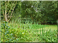
Pond, small park by Shaw Drive
The blue flowers look like Pickerel Weed, a garden plant of American origin. It is rather invasive, as are other plants in this pond.
Image: © Robin Webster
Taken: 1 Sep 2012
0.25 miles