IMAGES TAKEN NEAR TO
Cobham Park, COBHAM, KT11 3LE
Introduction
This page details the photographs taken nearby to Cobham Park, KT11 3LE by members of the Geograph project.
The Geograph project started in 2005 with the aim of publishing, organising and preserving representative images for every square kilometre of Great Britain, Ireland and the Isle of Man.

There are currently over 7.5m images from over14,400 individuals and you can help contribute to the project by visiting https://www.geograph.org.uk
Image Map
Images are licensed for reuse under creativecommons.org/licenses/by-sa/2.0
Notes
- Clicking on the map will re-center to the selected point.
- The higher the marker number, the further away the image location is from the centre of the postcode.
Image Listing (23 Images Found)
Images are licensed for reuse under creativecommons.org/licenses/by-sa/2.0
Image
Details
Distance
1
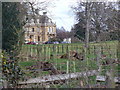
Cobham Park
Large mansion, in French renaissance style, set in extensive Mole Valley parkland. The mansion was home to the Combes, brewers, and was rebuilt in 1873 (Edward Middleton Barry, architect). The house was converted to office use (Eagle Star, 1939 and Logica, 1979) and in 2001 it was again sold, this time to become luxury apartments.
Image: © Colin Smith
Taken: 27 Feb 2011
0.04 miles
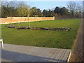
2
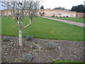
Walled Garden, Downside
Today, this is the "Medicine Garden" and is a popular open air cafe too. The walled garden is on Downside road, opposite the Cobham Park mansion.
Image: © Colin Smith
Taken: 27 Feb 2011
0.09 miles
3
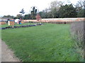
The Medicine Garden, Cobham
This is a converted farm with classes and little shops in the old stables.
Image: © David Howard
Taken: 3 Nov 2014
0.09 miles
4
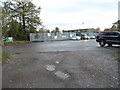
Car park by Downside Road, Cobham
Serving Challenge Fencing opposite and the Medicine Garden behind
Image: © David Howard
Taken: 3 Nov 2014
0.10 miles
5
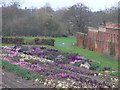
Purple Patch, Downside
The walled garden now contains the "Medicine Garden". Perhaps the purple herbs / vegetables are linked to it.
Image: © Colin Smith
Taken: 27 Feb 2011
0.11 miles
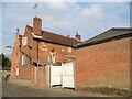
6
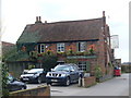
The Plough, Downside
Country pub and restaurant on Plough Lane, Downside - the southern edge of upmarket Cobham.
Image: © Colin Smith
Taken: 27 Feb 2011
0.12 miles
7
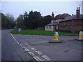
Plough Lane junction, Cobham
Junction with Bridge Road
Image: © David Howard
Taken: 12 Apr 2009
0.12 miles
8
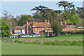
The Plough, Cobham
The Plough Inn on Plough Lane viewed from the Downside Way footpath.
Image: © Alan Hunt
Taken: 4 May 2016
0.13 miles
10
The Medicine Garden, Cobham
The Medicine Garden was converted from a stud farm in 2011 and sells plants and food as well as offering a variety of treatments and small shops.
Image: © David Howard
Taken: 12 Mar 2012
0.18 miles