IMAGES TAKEN NEAR TO
Lambourne Drive, COBHAM, KT11 3LB
Introduction
This page details the photographs taken nearby to Lambourne Drive, KT11 3LB by members of the Geograph project.
The Geograph project started in 2005 with the aim of publishing, organising and preserving representative images for every square kilometre of Great Britain, Ireland and the Isle of Man.

There are currently over 7.5m images from over14,400 individuals and you can help contribute to the project by visiting https://www.geograph.org.uk
Image Map
Images are licensed for reuse under creativecommons.org/licenses/by-sa/2.0
Notes
- Clicking on the map will re-center to the selected point.
- The higher the marker number, the further away the image location is from the centre of the postcode.
Image Listing (25 Images Found)
Images are licensed for reuse under creativecommons.org/licenses/by-sa/2.0
Image
Details
Distance
1
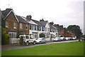
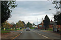
Tilt Road
View of the cottages at the west end of Tilt Road, part of The Tilt conservation area. At the far end of the row can be seen The Old Fire Station (see Image).
Image: © Ian Capper
Taken: 9 Sep 2008
0.08 miles
2
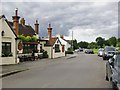
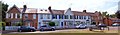
Tilt Road, Cobham
View north-westwards from outside 'The Running Mare' free house. The pub's name must date back to a time when horse racing took place on Tilt Common - before racing was confined to a handful of grand venues. In any case, the name belongs in a good Surrey tradition - along with 'The Running Horse' in Leatherhead, and 'The Running Horses' (to be found in both Mickleham and Dorking).
Image: © Stefan Czapski
Taken: 18 Sep 2013
0.09 miles
3
Memorial Plaque : Tilt Common
A memorial plaque was unveiled at the Avenue of Remembrance to remember those who lost their lives in the Second World War on the 26th April 2009. The plaque stands opposite Tilt Green, refer to picture Image
Image: © Len Williams
Taken: 4 Aug 2014
0.09 miles
4
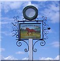
The Running Mare
The pub sign for 'The Running Mare' public house and restaurant, Cobham. Refer to picture Image for further details.
Image: © Len Williams
Taken: 4 Aug 2014
0.09 miles
5
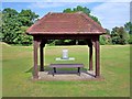
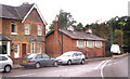
A245, Stoke Road
Ahead is a sort of village green, but maps do not give its title.
Image: © Robin Webster
Taken: 12 Nov 2011
0.09 miles
6
Gable Cottages : Tilt Green
This row of 9 houses overlooks Tilt Green. The central house has a title 'Gable Cottages 1901'. Refer to picture Image for a view of Tilt Green.
Image: © Len Williams
Taken: 4 Aug 2014
0.09 miles
7
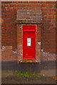
Victorian postbox, The Old Fire Station
Close up of the postbox in Image
Image: © Ian Capper
Taken: 9 Sep 2008
0.09 miles
8
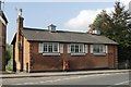
Cobham old fire station
Cobham old fire station, Tilt Road, Cobham, Surrey, now converted into a domestic dwelling
Image: © Kevin Hale
Taken: 6 Oct 2007
0.09 miles
9
The Old Fire Station, Tilt Road
Originally built in 1833 as Cobham's first purpose built school. It became the fire station around 1900. It is now a private house, but retains what is understood to be the original bells, as well as the fire house doors. The building is locally listed. For close up of the Victorian postbox in the wall, see Image
Image: © Ian Capper
Taken: 9 Sep 2008
0.09 miles
