IMAGES TAKEN NEAR TO
Brook Farm Road, COBHAM, KT11 3AX
Introduction
This page details the photographs taken nearby to Brook Farm Road, KT11 3AX by members of the Geograph project.
The Geograph project started in 2005 with the aim of publishing, organising and preserving representative images for every square kilometre of Great Britain, Ireland and the Isle of Man.

There are currently over 7.5m images from over14,400 individuals and you can help contribute to the project by visiting https://www.geograph.org.uk
Image Map
Images are licensed for reuse under creativecommons.org/licenses/by-sa/2.0
Notes
- Clicking on the map will re-center to the selected point.
- The higher the marker number, the further away the image location is from the centre of the postcode.
Image Listing (4 Images Found)
Images are licensed for reuse under creativecommons.org/licenses/by-sa/2.0
Image
Details
Distance
1
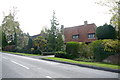
Houses on Fairmile Lane
These substantial suburban detached houses are on the lower section of Fairmile lane between the Stoke Rd the A425 and Knowle Hill Park
Image: © Nigel Mykura
Taken: 17 Apr 2015
0.23 miles
2
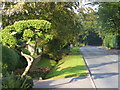
Water Lane, Cobham
Leafy road, lined with very upmarket and detached homes - ideal for rich commuters and rich retired commuters too.
Image: © Colin Smith
Taken: 17 Oct 2010
0.24 miles
3

Tilt Green
Part of The Tilt conservation area. Historically, the area was used for May Day celebrations, until stopped in 1902 due to complaints from the locals. Apparently the annual influx of gypsies and showmen proved too great an annoyance to the nearby residents. Cricket matches and horse racing also took place here in the past.
Image: © Ian Capper
Taken: 9 Sep 2008
0.24 miles
4
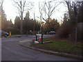
Junction of Fairmile Lane and Stoke Road
Image: © David Howard
Taken: 16 Jan 2012
0.25 miles