IMAGES TAKEN NEAR TO
Hawkhurst, COBHAM, KT11 2QX
Introduction
This page details the photographs taken nearby to Hawkhurst, KT11 2QX by members of the Geograph project.
The Geograph project started in 2005 with the aim of publishing, organising and preserving representative images for every square kilometre of Great Britain, Ireland and the Isle of Man.

There are currently over 7.5m images from over14,400 individuals and you can help contribute to the project by visiting https://www.geograph.org.uk
Image Map
Images are licensed for reuse under creativecommons.org/licenses/by-sa/2.0
Notes
- Clicking on the map will re-center to the selected point.
- The higher the marker number, the further away the image location is from the centre of the postcode.
Image Listing (14 Images Found)
Images are licensed for reuse under creativecommons.org/licenses/by-sa/2.0
Image
Details
Distance
1
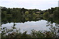
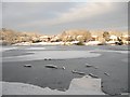
Littleheath Ponds
Littleheath Ponds are made up of one large and several smaller ponds situated where the clay pits were excavated for use in the adjacent Cook's brickwork factory. The largest 'pond' (pictured) is large enough to be considered a lake.
The large pond is also known locally as either 'Heathfield' or 'Brick Pit'.
Fishing is possible in the lake with a permit from the Cobham Court Angling Club.
Littleheath Common surrounding the lake is a local nature reserve maintained by Elmbridge Council.
Image: © Peter Clee
Taken: 15 Jul 2019
0.11 miles
3
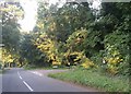
Entering Stoke D'Abernon
On the road from Oxshott.
Image: © Robin Webster
Taken: 21 Nov 2011
0.13 miles
4
Blundel Lane, Oxshott
At the end of Littleheath Lane
Image: © David Howard
Taken: 28 Aug 2017
0.14 miles
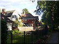
5
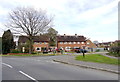
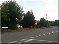
Houses on Waverley Road
These houses at the junction of Waverley Road and Blundells Lane which can be seen in the foreground appear to be social housing or ex social housing, i.e. former council houses. They are mostly semi-detached.
Image: © Nigel Mykura
Taken: 17 Apr 2015
0.14 miles
6
Brickfield pond
The pond was created by clay extraction for a brick works.
Image: © CBL
Taken: 7 Jan 2010
0.14 miles
7
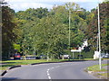
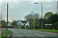
Entering Oxshott
On Blundel Lane, approaching the very leafy and upmarket village of Oxshott.
Image: © Colin Smith
Taken: 17 Oct 2010
0.17 miles
8
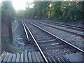
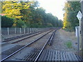
Railway lines south of level crossing, Littleheath Lane
Image: © David Howard
Taken: 19 Oct 2009
0.18 miles
9
Railway northbound from Blundel Lane level crossing
Image: © David Howard
Taken: 19 Oct 2009
0.18 miles
10
Little Heath Lane
In the commuting village of Fairmile, Cobham, next to Oxshott Heath.
Image: © Colin Smith
Taken: 17 Oct 2010
0.19 miles