IMAGES TAKEN NEAR TO
Beech Close, COBHAM, KT11 2EN
Introduction
This page details the photographs taken nearby to Beech Close, KT11 2EN by members of the Geograph project.
The Geograph project started in 2005 with the aim of publishing, organising and preserving representative images for every square kilometre of Great Britain, Ireland and the Isle of Man.

There are currently over 7.5m images from over14,400 individuals and you can help contribute to the project by visiting https://www.geograph.org.uk
Image Map
Images are licensed for reuse under creativecommons.org/licenses/by-sa/2.0
Notes
- Clicking on the map will re-center to the selected point.
- The higher the marker number, the further away the image location is from the centre of the postcode.
Image Listing (8 Images Found)
Images are licensed for reuse under creativecommons.org/licenses/by-sa/2.0
Image
Details
Distance
1
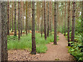
Pine plantation, Esher Common
The path runs parallel to the A3, to the right.
Image: © Robin Webster
Taken: 24 Aug 2012
0.18 miles
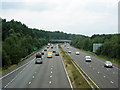
2
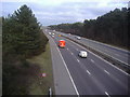
A3 eastbound, Esher
From the footbridge in Esher Common
Image: © David Howard
Taken: 8 Mar 2010
0.20 miles
3
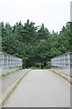
West Bridge, Esher Common
West Bridge is one of two bridges erected over the A3 to connect paths and rides bisected by the road. Although built as a carriageway bridge, it is seldom used by vehicles, and is designated as public bridleway Esher 54.
Image: © Hugh Craddock
Taken: 21 Jul 2013
0.22 miles
4
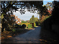
The Ridings
looking south-west from Sandy Lane
Image: © Andrew Longton
Taken: 11 Oct 2005
0.22 miles
5
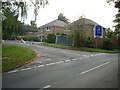
Sandy Drive, Fairmile
Short residential road of very nice houses.
Image: © Hugh Venables
Taken: 6 Nov 2010
0.23 miles
6

Entrance to footbridge over the A3, Esher Common
The start of the bridge from Esher to Oxshott on the Esher side.
Image: © David Howard
Taken: 8 Mar 2010
0.24 miles
7
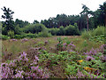
Open area, Esher Common
Largely wooded, sometimes deliberately so (as ahead), this open area shows what the common could be like.
Image: © Robin Webster
Taken: 24 Aug 2012
0.24 miles
8
A3 across Esher Common
Looking west from a bridleway bridge towards another. A carved sign on the viewpoint bridge was at first read as 'Ase Bridge', an odd name, until it dawned that it was actually 'A3, E Bridge'. In which case the distant bridge in this view must be A3, W Bridge.
Image: © Robin Webster
Taken: 24 Aug 2012
0.25 miles