IMAGES TAKEN NEAR TO
Cedar Road, COBHAM, KT11 2AE
Introduction
This page details the photographs taken nearby to Cedar Road, KT11 2AE by members of the Geograph project.
The Geograph project started in 2005 with the aim of publishing, organising and preserving representative images for every square kilometre of Great Britain, Ireland and the Isle of Man.

There are currently over 7.5m images from over14,400 individuals and you can help contribute to the project by visiting https://www.geograph.org.uk
Image Map
Images are licensed for reuse under creativecommons.org/licenses/by-sa/2.0
Notes
- Clicking on the map will re-center to the selected point.
- The higher the marker number, the further away the image location is from the centre of the postcode.
Image Listing (126 Images Found)
Images are licensed for reuse under creativecommons.org/licenses/by-sa/2.0
Image
Details
Distance
1
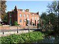
Cedar House Hotel
Hotel, with River Mole in the foreground.
Image: © Bryan Pready
Taken: 10 Sep 2006
0.05 miles
2

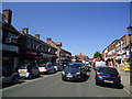
High Street
Few chain store outlets in the main shopping street of the exclusive Surrey town of Cobham.
Image: © Colin Smith
Taken: 6 May 2008
0.06 miles
4
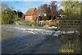
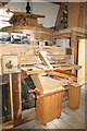
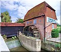
Cobham Mill and the River Mole
Originally there were two mills here with waterwheels between them. The older mill was demolished to enable Mill Road to be straightened in the early 1950s. The remaining mill building dates from 1822 and was in use grinding corn until the 1920s. The Cobham Mill Preservation Trust was set up in 1985 to restore the mill to full working order. It was opened to the public in 1993 and is a Grade II listed building. This view was taken on a day when the River Mole was in full spate.
Image: © Nigel Cox
Taken: 17 Mar 2002
0.08 miles
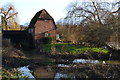
5
Cobham Grist Mill
Mills at Cobham have appeared in the records since the Domesday Book but the present mill, which was working until 1928, dates from the middle ages. The main part of the mill had to be demolished in 1953 as part of a road widening scheme leaving only the grist mill which has been fully restored. The adjoining sluice gate can be seen in picture Image
Image: © Len Williams
Taken: 4 Aug 2014
0.08 miles
6
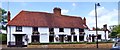
The Old Bear public house : Cobham
The (Old) Bear was built as farm house in the 15th or early 16th century and became a public house during the 18th century. The earliest recorded reference to the Bear is in a deed dated 1719 when Mary King of Cobham, widow, and John King her eldest son conveyed to Robert Patten of Ham, near Kingston, yeoman, 'All That freehold Messuage or Tenement or Inne situate and being in Coveham also Cobham aforesaid commonly called or known by the Signe of the Beare in or neare a certain street there called Church Street '.
Image: © Len Williams
Taken: 4 Aug 2014
0.08 miles
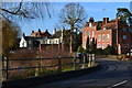
9
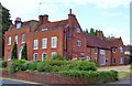
Cedar House : Cobham
Cedar House is a Grade II listed building. The core of the house dates from the 15th century however the front was built in the 18th century. The large stone traceried window dates from the 15th century but was brought from Yorkshire in the 20th century.
Image: © Len Williams
Taken: 4 Aug 2014
0.08 miles