IMAGES TAKEN NEAR TO
Meadway, ESHER, KT10 9HF
Introduction
This page details the photographs taken nearby to Meadway, KT10 9HF by members of the Geograph project.
The Geograph project started in 2005 with the aim of publishing, organising and preserving representative images for every square kilometre of Great Britain, Ireland and the Isle of Man.

There are currently over 7.5m images from over14,400 individuals and you can help contribute to the project by visiting https://www.geograph.org.uk
Image Map
Images are licensed for reuse under creativecommons.org/licenses/by-sa/2.0
Notes
- Clicking on the map will re-center to the selected point.
- The higher the marker number, the further away the image location is from the centre of the postcode.
Image Listing (30 Images Found)
Images are licensed for reuse under creativecommons.org/licenses/by-sa/2.0
Image
Details
Distance
1
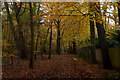
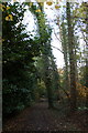
Path on the northern edge of Esher Common
Image: © Mike Pennington
Taken: 16 Nov 2017
0.11 miles
2
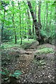
Derelict footbridge on Esher Common
Derelict footbridge over a ditch on Esher Common. The footbridge is part of a now overgrown and virtually untraceable footpath which ran parallel to the horse ride on the north perimeter of the common, and which is still shown on current Ordnance Survey Explorer maps.
Image: © Hugh Craddock
Taken: 21 Jul 2013
0.12 miles
3
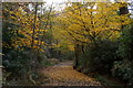
Path on the northern edge of Esher Common
Image: © Mike Pennington
Taken: 16 Nov 2017
0.14 miles
4
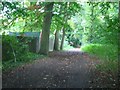
Bridleway on Esher Common
Looking north-east. To the left are the back garden fences of massive houses in Meadway.
Image: © Andrew Longton
Taken: 11 Oct 2005
0.15 miles
6
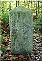
Old Milestone by Claremont Drive, Claremont Park
Carved stone post by the UC road, in parish of ESHER (ELMBRIDGE District), North East of Blackhills and end of Meadway (West side of Copsem Lane), near Fan Court School, North West of footpath, through derelict gate and past 'No Through Road' sign, on North side of road. Surrey limestone pillar, erected by the Surrey & Sussex turnpike trust in the 18th century.
Inscription reads:-
: XVII / Miles / III Quarters / from / West / minster / Bridge / 1762 : : XVII / Miles / II Furlongs / VIII Poles / From / Newcastle / House by / Hyde Park Corner : : XVIII Miles / From the / Standard / in / Cornhill / London / 1747 :
Carved benchmark on North East face.
Grade II* listed. List Entry Number: 1377464
https://historicengland.org.uk/listing/the-list/list-entry/1377464
Milestone Society National ID: SY_LCH18.
Image: © C Woodward
Taken: 1 Oct 2006
0.19 miles
7
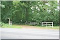
Equestrian crossing on Esher Common
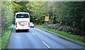
Equestrian crossing of Copsem Lane, giving access for horse riders between public bridleway Esher 46 off Arbrook Common, on the east side of the road, and the horse ride along the north perimeter of Esher Common on the west side. A finger post can be seen which identifies the horse ride, and a byelaws notice board, as well as a barrier to prevent vehicular access along the horse ride.
Image: © Hugh Craddock
Taken: 21 Jul 2013
0.21 miles
10
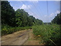
Cleared area for pylons on Esher Common
A long strip has been cut through the very middle of Esher Common to accommodate the pylons and created a new area of heathland.
Image: © David Howard
Taken: 25 Aug 2013
0.22 miles