IMAGES TAKEN NEAR TO
Winchester Close, ESHER, KT10 8QH
Introduction
This page details the photographs taken nearby to Winchester Close, KT10 8QH by members of the Geograph project.
The Geograph project started in 2005 with the aim of publishing, organising and preserving representative images for every square kilometre of Great Britain, Ireland and the Isle of Man.

There are currently over 7.5m images from over14,400 individuals and you can help contribute to the project by visiting https://www.geograph.org.uk
Image Map
Images are licensed for reuse under creativecommons.org/licenses/by-sa/2.0
Notes
- Clicking on the map will re-center to the selected point.
- The higher the marker number, the further away the image location is from the centre of the postcode.
Image Listing (14 Images Found)
Images are licensed for reuse under creativecommons.org/licenses/by-sa/2.0
Image
Details
Distance
1
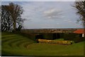
View From Esher Place
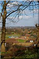
This is the view from the gardens of Image the body of water in the distance is Island Barn Reservoir if you have good eyes you might just be able to make out the arch of the New Wembley Stadium on the Horizon.
Image: © Glyn Baker
Taken: 26 Feb 2008
0.06 miles
2
Rear of Esher Place
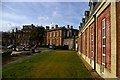
This is the rear elevation of Image, the training college of Unite the union. See http://www.amicustheunion.org/PDF/Esher%20History2.pdf for a full history.
Image: © Glyn Baker
Taken: 25 Feb 2008
0.07 miles
3
Esher Place
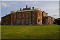
This is Esher Place the training college of Unite the union see http://www.amicustheunion.org/Default.aspx?page=111. Unite was formed by the merger of amicus and the T&GWU in 2007. The present building was built in the early 19th Century in the style of a French chateaux. In the 1930’s it was converted for use as a Girls School, in 1953 it became the U.K’s first residential training establishment for trades union reps. The Electricians Union paid £23,000 for it. The view is looking along the recently constructed residential block towards the main house. You can read a full history at http://www.amicustheunion.org/PDF/Esher%20History2.pdf
Image: © Glyn Baker
Taken: 25 Feb 2008
0.09 miles
4
Tulip Tree Plaque
Image: © Glyn Baker
Taken: 26 Feb 2008
0.09 miles
5
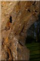
Tulip Bark
Image: © Glyn Baker
Taken: 26 Feb 2008
0.09 miles
6
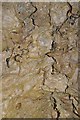
Bark of the Tulip Tree
Image: © Glyn Baker
Taken: 26 Feb 2008
0.09 miles
7
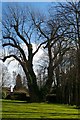
Tulip Tree
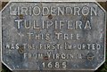
The large tree is the oldest example of a Tulip Tree Liriodendron tulipifera in the country it stands in the grounds of
Image it was planted in 1685 see Image
Its bark has fantastic shapes see Image
Image: © Glyn Baker
Taken: 26 Feb 2008
0.10 miles
8

Esher's Venus
Image: © Glyn Baker
Taken: 26 Feb 2008
0.10 miles
9
Esher Amphitheatre
This is the Edwin Lutyens designed amphitheatre in the grounds of Image
Image: © Glyn Baker
Taken: 25 Feb 2008
0.12 miles
10

Wayneflete's Tower
Wayneflete's Tower was originally an 11th century manorial complex, sited on the banks of the River Mole. In 1462, Bishop William Waynflete of Winchester, founded the brick Palace of Esher and incorporated the medieval stone fortified manor house. The four storey gatehouse, with semi-octagonal turrets to the fore, was linked by a high curtain wall to a huge brick keep, which had octagonal turrets on the angles. Sadly in 17th century, the keep, the great hall, the curtain wall and associated building ranges were all demolished, down to the foundations. In the 18th century, Henry Pelham added a pair of wings and a porch, when integrating the tower into a Gothic mansion house.
Image: © Walter Koscielniak
Taken: 23 Mar 2008
0.14 miles