IMAGES TAKEN NEAR TO
Monkton, PRESTWICK, KA9 2SN
Introduction
This page details the photographs taken nearby to KA9 2SN by members of the Geograph project.
The Geograph project started in 2005 with the aim of publishing, organising and preserving representative images for every square kilometre of Great Britain, Ireland and the Isle of Man.

There are currently over 7.5m images from over14,400 individuals and you can help contribute to the project by visiting https://www.geograph.org.uk
Image Map
Images are licensed for reuse under creativecommons.org/licenses/by-sa/2.0
Notes
- Clicking on the map will re-center to the selected point.
- The higher the marker number, the further away the image location is from the centre of the postcode.
Image Listing (37 Images Found)
Images are licensed for reuse under creativecommons.org/licenses/by-sa/2.0
Image
Details
Distance
8
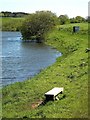
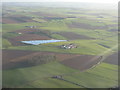
Raith Reservoir
The shoreline at the far end of Raith Reservoir. Fishing is for members of Prestwick Angling Club.
Image: © Mary and Angus Hogg
Taken: 12 May 2009
0.12 miles
9
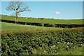
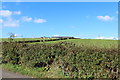
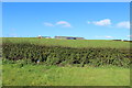
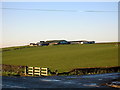
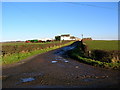
Farmland View At Raith
Typical farmland in the Kyle district of Ayrshire - rich grazing land and silage fields for dairy cattle. Viewed in mid-May.
Image: © Mary and Angus Hogg
Taken: 12 May 2009
0.13 miles
10
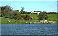
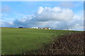
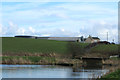
Raith Reservoir View
Looking across the reservoir towards Tarshaw Farm, in this square. Viewed on a breezy day in mid-May, when no one was catching anything.
Image: © Mary and Angus Hogg
Taken: 12 May 2009
0.14 miles