IMAGES TAKEN NEAR TO
Baird Road, PRESTWICK, KA9 2RE
Introduction
This page details the photographs taken nearby to Baird Road, KA9 2RE by members of the Geograph project.
The Geograph project started in 2005 with the aim of publishing, organising and preserving representative images for every square kilometre of Great Britain, Ireland and the Isle of Man.

There are currently over 7.5m images from over14,400 individuals and you can help contribute to the project by visiting https://www.geograph.org.uk
Image Map (85 Images)
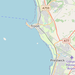


Leaflet Map data © OpenStreetMap
Images are licensed for reuse under creativecommons.org/licenses/by-sa/2.0
Notes
- Clicking on the map will re-center to the selected point.
- The higher the marker number, the further away the image location is from the centre of the postcode.
Image Listing (85 Images Found)
Images are licensed for reuse under creativecommons.org/licenses/by-sa/2.0
Image
Details
Distance
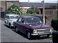
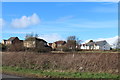
1
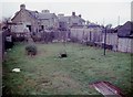
The rear of houses on Kilmarnock Road, Monkton
Image: © Alan Reid
Taken: 23 Jan 1976
0.09 miles
3
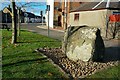
The Muckle Stane
The information plaque reads:
MONKTON HISTORICAL SOCIETY
THE MUCKLE STANE
(ERRATIC BOULDER)
ARRIVED AT END OF ICE AGE
TO MAP REF. 285360
PLACED HERE ON 29th SEPT. 1998
PLAQUE DONATED BY
SOUTH AYRSHIRE COUNCIL
Image: © Mary and Angus Hogg
Taken: 10 Nov 2010
0.10 miles
5
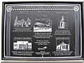
Monkton Heritage
Information plaque with details of Monkton's history and connection with the aviation industry at Prestwick.
Image: © M J Richardson
Taken: 15 Jun 2010
0.10 miles
7
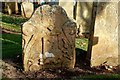
Symbolic Gravestone at Monkton
A fine old carved stone in St Cuthberts Graveyard, Monkton. It was not possible to read the inscription on the other side but the carved tools show that the deceased was a wright.
Image: © Mary and Angus Hogg
Taken: 10 Nov 2010
0.11 miles
8
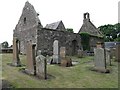
St Cuthbert's Church
Ruins of the 13th Century Church at Monkton, founded by the monks of Paisley Abbey and used for worship until the 19th Century..
Image: © M J Richardson
Taken: 15 Jun 2010
0.11 miles
9
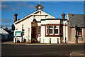
Monkton Community Centre
This local centre is operated by South Ayrshire Council. Will it survive the forthcoming cuts in response to the credit crunch....?
Image: © Mary and Angus Hogg
Taken: 10 Nov 2010
0.11 miles