IMAGES TAKEN NEAR TO
Macrae Drive, PRESTWICK, KA9 1NY
Introduction
This page details the photographs taken nearby to Macrae Drive, KA9 1NY by members of the Geograph project.
The Geograph project started in 2005 with the aim of publishing, organising and preserving representative images for every square kilometre of Great Britain, Ireland and the Isle of Man.

There are currently over 7.5m images from over14,400 individuals and you can help contribute to the project by visiting https://www.geograph.org.uk
Image Map
Images are licensed for reuse under creativecommons.org/licenses/by-sa/2.0
Notes
- Clicking on the map will re-center to the selected point.
- The higher the marker number, the further away the image location is from the centre of the postcode.
Image Listing (142 Images Found)
Images are licensed for reuse under creativecommons.org/licenses/by-sa/2.0
Image
Details
Distance
2
Macrae Drive From The Seagate
This old road, called The Seagate, leads to a very low bridge underneath the railway line.
Image: © Mary and Angus Hogg
Taken: 29 Dec 2008
0.04 miles
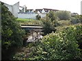
3
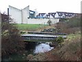
Disused railway bridge
Crossing a polluted looking Pow Burn near Prestwick Airport.
Image: © Thomas Nugent
Taken: 27 Jan 2009
0.05 miles
4
Pow Burn, Prestwick
Hogweed and graffiti blighted river banks.
Image: © Richard Webb
Taken: 9 Sep 2009
0.08 miles
5
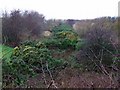
Disused railway line
A well overgrown line, running parallel with the A79 near Prestwick Airport.
Image: © Thomas Nugent
Taken: 27 Jan 2009
0.09 miles
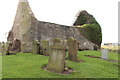
6
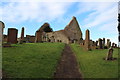
St Nicholas' Church & Graveyard, Prestwick
Image: © Billy McCrorie
Taken: 7 Feb 2014
0.09 miles
7
St Nicholas' Church & Graveyard, Prestwick
Image: © Billy McCrorie
Taken: 7 Feb 2014
0.09 miles
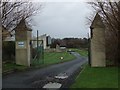
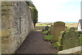
8
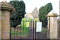
Gateway to St Nicholas' Church & Graveyard
Image: © Billy McCrorie
Taken: 7 Feb 2014
0.09 miles
9
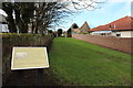
Path to St Nicholas' Church & Graveyard, Prestwick
Image: © Billy McCrorie
Taken: 7 Feb 2014
0.09 miles