IMAGES TAKEN NEAR TO
Dunure, AYR, KA7 4LH
Introduction
This page details the photographs taken nearby to KA7 4LH by members of the Geograph project.
The Geograph project started in 2005 with the aim of publishing, organising and preserving representative images for every square kilometre of Great Britain, Ireland and the Isle of Man.

There are currently over 7.5m images from over14,400 individuals and you can help contribute to the project by visiting https://www.geograph.org.uk
Image Map
Images are licensed for reuse under creativecommons.org/licenses/by-sa/2.0
Notes
- Clicking on the map will re-center to the selected point.
- The higher the marker number, the further away the image location is from the centre of the postcode.
Image Listing (13 Images Found)
Images are licensed for reuse under creativecommons.org/licenses/by-sa/2.0
Image
Details
Distance
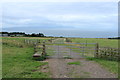
1
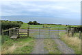
Dunduff Farm
From the hill path to Dunure.
Image: © Billy McCrorie
Taken: 24 Aug 2013
0.06 miles
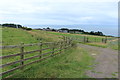
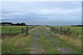
2
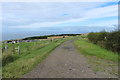
Road to Dunduff Farm
From the hill path to Dunure.
Image: © Billy McCrorie
Taken: 24 Aug 2013
0.09 miles
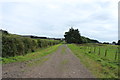
4
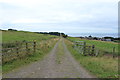
Hill Path to Dunure with Stile
Over the stile and turn right. View over to the Isle of Arran.
Image: © Billy McCrorie
Taken: 24 Aug 2013
0.11 miles
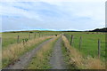
5
Hill Path to Dunure with Waymarker
On the mid left is Fisherton.
Image: © Billy McCrorie
Taken: 24 Aug 2013
0.13 miles
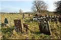
7
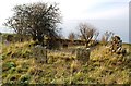
Kirkbride Church Remains
The church of St Bridget existed here around 1185 when the parish was granted to the nuns of North Berwick. The parish was united with Maybole soon after 1571. The last burial was in 1913. The site contains a few ruins of the building and some stones that are difficult to decipher.
Image: © Mary and Angus Hogg
Taken: 27 Feb 2016
0.20 miles
8
Kirkbride Church
The church of St Bridget existed here around 1185 when the parish was granted to the nuns of North Berwick. The parish was united with Maybole soon after 1571. The last burial was in 1913. The site contains a few ruins of the building and some stones that are difficult to decipher.
Image: © Mary and Angus Hogg
Taken: 27 Feb 2016
0.20 miles
9
Hill Path to Dunure with Waymarker
With view over to the Isle of Arran.
Image: © Billy McCrorie
Taken: 24 Aug 2013
0.21 miles