IMAGES TAKEN NEAR TO
Hartfield Road, AYR, KA7 2RN
Introduction
This page details the photographs taken nearby to Hartfield Road, KA7 2RN by members of the Geograph project.
The Geograph project started in 2005 with the aim of publishing, organising and preserving representative images for every square kilometre of Great Britain, Ireland and the Isle of Man.

There are currently over 7.5m images from over14,400 individuals and you can help contribute to the project by visiting https://www.geograph.org.uk
Image Map
Images are licensed for reuse under creativecommons.org/licenses/by-sa/2.0
Notes
- Clicking on the map will re-center to the selected point.
- The higher the marker number, the further away the image location is from the centre of the postcode.
Image Listing (117 Images Found)
Images are licensed for reuse under creativecommons.org/licenses/by-sa/2.0
Image
Details
Distance
1
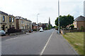
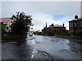
St. Leonards Road
Maybole Road has now changed its name to St. Leonards Road, though where the boundary is between the two and where the name actually changes I am not sure.
Image: © Malcolm Neal
Taken: 4 Jul 2021
0.04 miles
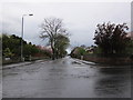
5
Monument Road
From the junction with Corsehill Road.
Image: © Billy McCrorie
Taken: 24 Apr 2012
0.06 miles
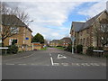
6
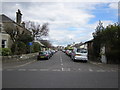
Hazelwood Road
From St Leonard's Road.
Image: © Billy McCrorie
Taken: 31 Mar 2012
0.06 miles
7
Corsehill Road
From the Monument Road.
Image: © Billy McCrorie
Taken: 24 Apr 2012
0.08 miles
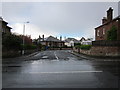
9
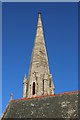
Steeple, St Leonard's Parish Church, Ayr
Image: © Billy McCrorie
Taken: 6 Feb 2018
0.08 miles
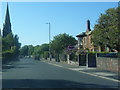
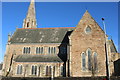
10

St Leonards Parish Church in Ayr
Viewed from the north-west.
Image: © Peter Wood
Taken: 12 Sep 2016
0.08 miles