IMAGES TAKEN NEAR TO
South Harbour Street, AYR, KA7 1JA
Introduction
This page details the photographs taken nearby to South Harbour Street, KA7 1JA by members of the Geograph project.
The Geograph project started in 2005 with the aim of publishing, organising and preserving representative images for every square kilometre of Great Britain, Ireland and the Isle of Man.

There are currently over 7.5m images from over14,400 individuals and you can help contribute to the project by visiting https://www.geograph.org.uk
Image Map
Images are licensed for reuse under creativecommons.org/licenses/by-sa/2.0
Notes
- Clicking on the map will re-center to the selected point.
- The higher the marker number, the further away the image location is from the centre of the postcode.
Image Listing (731 Images Found)
Images are licensed for reuse under creativecommons.org/licenses/by-sa/2.0
Image
Details
Distance
1
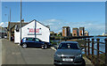
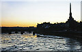
The former Coffee Boat site
To compare this view with something similar from May 2000, see Image The Boathouse restaurant is still there now but the Coffee Boat has become a physiotherapy business. The harbour-side and seafront flats have been completed and the Citadel Leisure Centre is now threatened with closure in favour of a new facility in the town centre.
Image: © Mary and Angus Hogg
Taken: 17 Jun 2021
0.01 miles
2
The Coffee Boat at Ayr Harbour, May 2000
This shot of Ayr South Harbour was taken in May 2000. The Boathouse restaurant is still there in 2021 but the Coffee Boat has become a physiotherapy business. By May 2000, the harbour was being developed for residential use with the first blocks completed and the rest under construction. The newly-opened Citadel Leisure Centre is just visible behind the flats. 21 years on, the site looks like Image
Image: © Mary and Angus Hogg
Taken: Unknown
0.01 miles
3
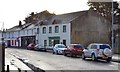
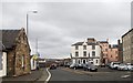
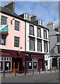
South Harbour Street, Ayr, South Ayrshire
Looking towards Ye Olde Forte Bar on South Harbour Street.
Image: © Mark S
Taken: 18 Jan 2020
0.02 miles
4
Ayr Harbour frozen, January 1979
Ayrshire normally has mild, wet winter weather but January 1979 was unusually cold. This early-morning shot shows ice right across Ayr Harbour. The view is looking upstream with the Town Hall spire on the far right.
Image: © Mary and Angus Hogg
Taken: Unknown
0.03 miles
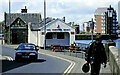
6
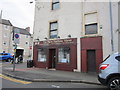
The New Harbour Views on South Harbour Street, Ayr
Image: © Ian S
Taken: 24 Aug 2013
0.04 miles
7
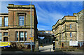
Ayr Grammar Campus entrance
The old Ayr Academy building in Fort Street has been transformed into Ayr Grammar Campus to replace the old town-centre primary school shown at Image £16 million has been invested into the project which also accommodates an early years centre and community space. Ayr Grammar Primary School opened here in early 2021. This view shows the main entrance.
Image: © Mary and Angus Hogg
Taken: 17 Mar 2021
0.04 miles
8
Ayr's Malt Cross - Where Witches Were Burned
The pub in this photo takes its name from the old Malt Cross of Ayr which formerly stood at the junction of High Street and the Sandgate. The exact location is marked by cobbled stones in the tarmac in the foreground of this photo. This was the place where the witch, Maggie Osborne, was burnt to death in 1629 - see Image The Malt Cross was removed in 1778 as it was obstructing the flow of traffic. (Source: “Ayrshire: Discovering A County”, by Dane Love.) An incident involving William Wallace is noted in Image
Image: © Mary and Angus Hogg
Taken: 28 Apr 2009
0.04 miles
9
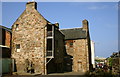
Loudon Hall
Loudoun Hall is one of the oldest buildings in Ayr, late 1400's and is situated in the Boat Vennel, which is near the bottom of the High Street.
It was built for a James Tait, wealthy merchant who traded with European countries. In the 16th Century, it became the townhouse for the Campbells of Loudoun, the heridary sheriffs of Ayr.
Image: © George Rankin
Taken: 5 May 2007
0.05 miles