IMAGES TAKEN NEAR TO
Park Crescent, AYR, KA6 7RR
Introduction
This page details the photographs taken nearby to Park Crescent, KA6 7RR by members of the Geograph project.
The Geograph project started in 2005 with the aim of publishing, organising and preserving representative images for every square kilometre of Great Britain, Ireland and the Isle of Man.

There are currently over 7.5m images from over14,400 individuals and you can help contribute to the project by visiting https://www.geograph.org.uk
Image Map
Images are licensed for reuse under creativecommons.org/licenses/by-sa/2.0
Notes
- Clicking on the map will re-center to the selected point.
- The higher the marker number, the further away the image location is from the centre of the postcode.
Image Listing (55 Images Found)
Images are licensed for reuse under creativecommons.org/licenses/by-sa/2.0
Image
Details
Distance
1
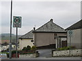
Road sign showing speed limit - "Twenty's plenty"
These road signs are in Dalmellington and they are different. They mark a change from 30 miles per hour down to twenty. And it's done in an amusing way which certainly makes you notice them - - "Twenty's Plenty"!
Image: © Ann Cook
Taken: 23 Apr 2009
0.07 miles
2

Dalmellington from the air
Looking southwest en route south from Prestwick.
Image: © M J Richardson
Taken: 25 Aug 2013
0.07 miles
4

Miners' Row at Broomknowe
Three rows of these brick-built houses were erected by the colliery owners around 1910-1912 at Broomknowe. They were regarded as a model development, giving greatly improved living conditions for the miners' families and their continued existence confirms this. Most miners' rows were demolished as slums long ago. Similar long-standing colliery houses can be seen at Girvan Image
Image: © Mary and Angus Hogg
Taken: 29 May 2016
0.08 miles
7
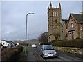
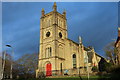
Dalmellington Parish Church
Dalmellington Parish Church stands in a commanding position at the N side of town on Knowehead (parallel with High Main St). Built 1846 of local Dunaskin sandstone, it was formerly known as "The Kirk o` The Covenant".
Image: © Chris Newman
Taken: 7 Feb 2008
0.09 miles
8
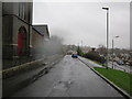
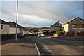
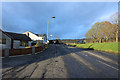
Knowehead Road
The road passing Dalmellinton Parish Church on the left.
Image: © Billy McCrorie
Taken: 4 Jan 2012
0.10 miles
9
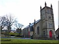
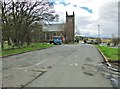
Dalmellington Parish Church
Formerly known as the 'Kirk o' the Covenant', the red doors are said to symbolise the blood of the Covenanting martyrs.
Image: © Becky Williamson
Taken: 14 Feb 2011
0.10 miles