IMAGES TAKEN NEAR TO
AYR, KA6 6LR
Introduction
This page details the photographs taken nearby to KA6 6LR by members of the Geograph project.
The Geograph project started in 2005 with the aim of publishing, organising and preserving representative images for every square kilometre of Great Britain, Ireland and the Isle of Man.

There are currently over 7.5m images from over14,400 individuals and you can help contribute to the project by visiting https://www.geograph.org.uk
Image Map
Images are licensed for reuse under creativecommons.org/licenses/by-sa/2.0
Notes
- Clicking on the map will re-center to the selected point.
- The higher the marker number, the further away the image location is from the centre of the postcode.
Image Listing (9 Images Found)
Images are licensed for reuse under creativecommons.org/licenses/by-sa/2.0
Image
Details
Distance
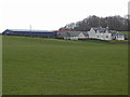
3
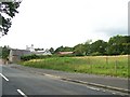
Drive to Sundrum Holiday Park
Barclaugh in the distance.
Image: © wfmillar
Taken: 6 Feb 2012
0.19 miles
4
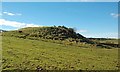
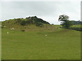
Witch Knowe
An ancient mound near Coylton, whose origin is lost in the mists of time.
Image: © Mary and Angus Hogg
Taken: 10 Mar 2016
0.19 miles
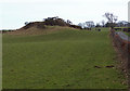
5
Witch Knowe, Coylton
One of many mounds with this name. It could be a tumulus, a motte. or maybe just natural. See Image for another image of it (with sunshine!).
Image: © Humphrey Bolton
Taken: 10 Oct 2017
0.19 miles
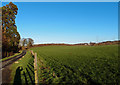
6
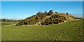
Mound near Westpark Farm
Known as Witch Knowe.
Image: © wfmillar
Taken: 13 Feb 2012
0.20 miles
7
Witch Knowe View
An ancient mound near Coylton, whose origin is lost in the mists of time.
Image: © Mary and Angus Hogg
Taken: 10 Mar 2016
0.20 miles
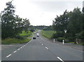
9
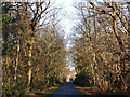
Wooded Drive
Drive to Sundrum Holiday Park.
Image: © wfmillar
Taken: 6 Feb 2012
0.22 miles