IMAGES TAKEN NEAR TO
Sundrum, AYR, KA6 5LB
Introduction
This page details the photographs taken nearby to KA6 5LB by members of the Geograph project.
The Geograph project started in 2005 with the aim of publishing, organising and preserving representative images for every square kilometre of Great Britain, Ireland and the Isle of Man.

There are currently over 7.5m images from over14,400 individuals and you can help contribute to the project by visiting https://www.geograph.org.uk
Image Map (Loading...)


Getting Data...Please wait
Leaflet Map data © OpenStreetMap
Images are licensed for reuse under creativecommons.org/licenses/by-sa/2.0
Notes
- Clicking on the map will re-center to the selected point.
- The higher the marker number, the further away the image location is from the centre of the postcode.
Image Listing (4 Images Found)
Images are licensed for reuse under creativecommons.org/licenses/by-sa/2.0
Image
Details
Distance
1
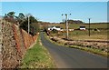
Towards Broadwood
The house at the junction lies in the next square.
Image: © Mary and Angus Hogg
Taken: 7 Mar 2016
0.03 miles
3
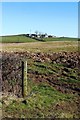
Towards Raithhill
The rolling land here was produced during the last glaciation when moving ice sheets deposited drumlins. Their heavy, sticky soils provide good grazing land. Raithhill Farm, sited on the edge of a drumlin, lies in the next square.
Image: © Mary and Angus Hogg
Taken: 7 Mar 2016
0.13 miles
4
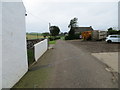
Track to road (B742) from Raithill Farm
Looking north-westward.
Image: © Peter Wood
Taken: 12 Sep 2016
0.23 miles