IMAGES TAKEN NEAR TO
Auchinleck Road, MAUCHLINE, KA5 6SL
Introduction
This page details the photographs taken nearby to Auchinleck Road, KA5 6SL by members of the Geograph project.
The Geograph project started in 2005 with the aim of publishing, organising and preserving representative images for every square kilometre of Great Britain, Ireland and the Isle of Man.

There are currently over 7.5m images from over14,400 individuals and you can help contribute to the project by visiting https://www.geograph.org.uk
Image Map
Images are licensed for reuse under creativecommons.org/licenses/by-sa/2.0
Notes
- Clicking on the map will re-center to the selected point.
- The higher the marker number, the further away the image location is from the centre of the postcode.
Image Listing (64 Images Found)
Images are licensed for reuse under creativecommons.org/licenses/by-sa/2.0
Image
Details
Distance
1
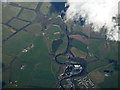
Catrine from the air
The bonded warehouses in a meander of the River Ayr are prominent. These stand of the site of the cotton mills which were opened here by David Dale and Claude Alexander in 1787 and which closed in 1968. The reservoirs to the left are remnants of the mills.
Image: © Thomas Nugent
Taken: 17 Apr 2017
0.02 miles
2
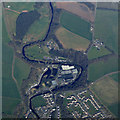
Catrine from the air
The bonded warehouses in a meander of the River Ayr are prominent. These stand of the site of the cotton mills which were opened here by David Dale and Claude Alexander in 1787 and which closed in 1968. The reservoirs to the left are remnants of the mills.
Image: © Thomas Nugent
Taken: 17 Apr 2017
0.05 miles
3
Catrine - woodland opposite Blackwood Avenue
Image: © Leslie Barrie
Taken: 5 Nov 2012
0.08 miles
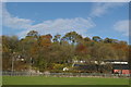
4
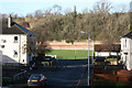
Recreation Area
Area used for football lying between the council houses in the foreground and the R. Ayr. Some flood protection needed here - shown by the red walls in the middle distance. The war memorial dominates the top of the wooded valley side.
Image: © Bob Forrest
Taken: 17 Jan 2007
0.09 miles
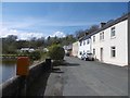
5
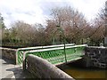
Bridge, St Cuthbert Street
Bridge over a lade in Catrine. The lade is part of the power system for the mills, taking water from the voes, (holding ponds). A weir diverts water to the voes from the River Ayr.
Image: © Richard Webb
Taken: 5 May 2016
0.10 miles
6
Bonded Warehouse
New use for part of the old cotton mill in Catrine which operated until the late 1960 period. This is now a bonded warehouse for whisky.
Image: © Bob Forrest
Taken: 17 Jan 2007
0.11 miles
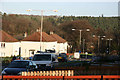
7
Catrine - view from the Football Ground
Image: © Leslie Barrie
Taken: 5 Nov 2012
0.11 miles
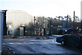
8
Exit on to B713 to Auchinleck
Lower part of the Shawwood council housing estate. This is one of the main access roads into the scheme from the B713.
Image: © Bob Forrest
Taken: 17 Jan 2007
0.11 miles
10
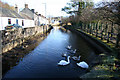
Mill Lade
This man-made channel led the water from the first reservoir (voe), from which water was drawn off to power the mill wheel in the waulk mill, to the second voe which provided water for the giant water wheel in the main mill in the centre of Catrine.
Image: © Bob Forrest
Taken: 17 Jan 2007
0.13 miles