IMAGES TAKEN NEAR TO
Sorn, MAUCHLINE, KA5 6NG
Introduction
This page details the photographs taken nearby to KA5 6NG by members of the Geograph project.
The Geograph project started in 2005 with the aim of publishing, organising and preserving representative images for every square kilometre of Great Britain, Ireland and the Isle of Man.

There are currently over 7.5m images from over14,400 individuals and you can help contribute to the project by visiting https://www.geograph.org.uk
Image Map
Images are licensed for reuse under creativecommons.org/licenses/by-sa/2.0
Notes
- Clicking on the map will re-center to the selected point.
- The higher the marker number, the further away the image location is from the centre of the postcode.
Image Listing (7 Images Found)
Images are licensed for reuse under creativecommons.org/licenses/by-sa/2.0
Image
Details
Distance
3
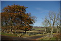
Glendale Woodland
This is a recent woodland project on the northern edge of Airds Moss. The land here is wet and boggy by nature which makes it less attractive for farming activities although sheep are run on parts of Airds Moss.
Image: © Bob Forrest
Taken: 18 Feb 2007
0.14 miles
5
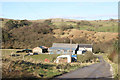
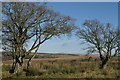
Mid-Heilar
A small collection of farm buildings and a dwelling house located above the floodplain of the R.Ayr. The floodplain starts to widen here after the gorge section which extends downstream for about 2km from Upper Heilar.
Image: © Bob Forrest
Taken: 18 Feb 2007
0.20 miles
6
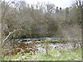
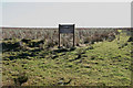
River Ayr
Here the north bank is gentle and farmed with an arable haugh, while the south bank is steep and craggy.
Image: © Richard Webb
Taken: 5 May 2016
0.20 miles
7
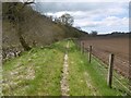
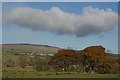
River Ayr Way
Crossing the Merkland Burn is quite a landmark. Downstream, arable farmland appears while the path crosses steep ground and bogs upstream. The south bank contrasts with this gentle scene here, it is steep with wet loose crags.
Image: © Richard Webb
Taken: 5 May 2016
0.21 miles