IMAGES TAKEN NEAR TO
Sorn, MAUCHLINE, KA5 6JH
Introduction
This page details the photographs taken nearby to KA5 6JH by members of the Geograph project.
The Geograph project started in 2005 with the aim of publishing, organising and preserving representative images for every square kilometre of Great Britain, Ireland and the Isle of Man.

There are currently over 7.5m images from over14,400 individuals and you can help contribute to the project by visiting https://www.geograph.org.uk
Image Map
Images are licensed for reuse under creativecommons.org/licenses/by-sa/2.0
Notes
- Clicking on the map will re-center to the selected point.
- The higher the marker number, the further away the image location is from the centre of the postcode.
Image Listing (3 Images Found)
Images are licensed for reuse under creativecommons.org/licenses/by-sa/2.0
Image
Details
Distance
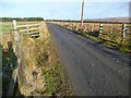
1
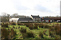
Meadowhead
Located above the Burn o'Need in an area where the land is very heavy and wet in the absence of a natural slope. The main farming interest appears to be in the rearing of beef cattle and sheep.
Image: © Bob Forrest
Taken: 17 Feb 2007
0.01 miles
2
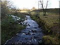
Burn O' Need
At Wealth of Waters, looking upstream.
Image: © Gordon Brown
Taken: 19 Jan 2011
0.21 miles