IMAGES TAKEN NEAR TO
Woodlands Road, MAUCHLINE, KA5 6HZ
Introduction
This page details the photographs taken nearby to Woodlands Road, KA5 6HZ by members of the Geograph project.
The Geograph project started in 2005 with the aim of publishing, organising and preserving representative images for every square kilometre of Great Britain, Ireland and the Isle of Man.

There are currently over 7.5m images from over14,400 individuals and you can help contribute to the project by visiting https://www.geograph.org.uk
Image Map
Images are licensed for reuse under creativecommons.org/licenses/by-sa/2.0
Notes
- Clicking on the map will re-center to the selected point.
- The higher the marker number, the further away the image location is from the centre of the postcode.
Image Listing (21 Images Found)
Images are licensed for reuse under creativecommons.org/licenses/by-sa/2.0
Image
Details
Distance


7
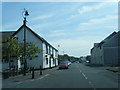
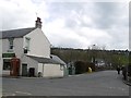
Cafe and shop, Sorn
Closed, not sure if that was temporary or not.
Image: © Richard Webb
Taken: 11 May 2021
0.05 miles
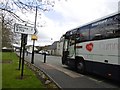
8
Junction, Sorn
There is a bridge over the Ayr here as well as a cafe. However as I was not a local and that they close at 15:00 they declined to serve me at all at 14:50. Pointing out the time and that others were being served provoked a pretty startling reaction - cornered!
The shop's fine btw.
Image: © Richard Webb
Taken: 5 May 2016
0.06 miles
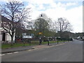
9
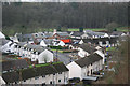
Council Housing
A crescent of council built houses from the mid 1950 period located back from the main street in Sorn. The building with the cream coloured tower is the primary school, built in 1850 and still in use to-day. Opposite the school and fitting in with the concept of a conservation village, are local authority housing reminiscent of the traditional thatched cottages which once occupied this part of Sorn, or Dalgain, which was the original name for the village.
Image: © Bob Forrest
Taken: 2 Feb 2007
0.07 miles
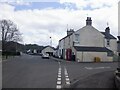
10
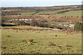
Sorn,Conservation Village
This shows the geographical location of Sorn from the south-east. The village over the course of time has expanded over the floodplain of the R.Ayr to the steep slopes marking the edge of a former floodplain. The generally flat feature above the village,backed by the gentle slopes rising up to Blindburn Farm in the photograph, is called a river terrace.
Image: © Bob Forrest
Taken: 18 Feb 2007
0.08 miles