IMAGES TAKEN NEAR TO
MAUCHLINE, KA5 6HH
Introduction
This page details the photographs taken nearby to KA5 6HH by members of the Geograph project.
The Geograph project started in 2005 with the aim of publishing, organising and preserving representative images for every square kilometre of Great Britain, Ireland and the Isle of Man.

There are currently over 7.5m images from over14,400 individuals and you can help contribute to the project by visiting https://www.geograph.org.uk
Image Map
Images are licensed for reuse under creativecommons.org/licenses/by-sa/2.0
Notes
- Clicking on the map will re-center to the selected point.
- The higher the marker number, the further away the image location is from the centre of the postcode.
Image Listing (6 Images Found)
Images are licensed for reuse under creativecommons.org/licenses/by-sa/2.0
Image
Details
Distance
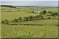
1
Grassyards
The original farmhouse has been much extended. The buildings lie alongside the B743 between Mauchline and Sorn.
Image: © Richard Dorrell
Taken: 28 Sep 2012
0.02 miles
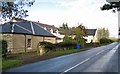
2
Grassyards
House and small collection of farm buildings on the side of the B743 from Mauchline to Sorn. In the distance is the ridge known as Blackside.
Image: © Bob Forrest
Taken: 22 Jan 2007
0.02 miles
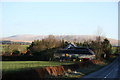
3
B743 towards Mauchline
A small patch of mixed woodland grows on the hillside to the south of the road.
Image: © Richard Dorrell
Taken: 28 Sep 2012
0.07 miles
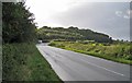
4
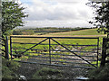
Field entrance
Pastureland east of Mauchline, very soggy at the moment after a very wet summer. No stock are grazing here at present.
Image: © Richard Dorrell
Taken: 28 Sep 2012
0.12 miles
5
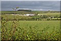
Over the fields towards Garfield
A rural scene east of Mauchline. The farm buildings lie just into grid square Image
Image: © Richard Dorrell
Taken: 28 Sep 2012
0.15 miles