IMAGES TAKEN NEAR TO
MAUCHLINE, KA5 5TA
Introduction
This page details the photographs taken nearby to KA5 5TA by members of the Geograph project.
The Geograph project started in 2005 with the aim of publishing, organising and preserving representative images for every square kilometre of Great Britain, Ireland and the Isle of Man.

There are currently over 7.5m images from over14,400 individuals and you can help contribute to the project by visiting https://www.geograph.org.uk
Image Map
Images are licensed for reuse under creativecommons.org/licenses/by-sa/2.0
Notes
- Clicking on the map will re-center to the selected point.
- The higher the marker number, the further away the image location is from the centre of the postcode.
Image Listing (5 Images Found)
Images are licensed for reuse under creativecommons.org/licenses/by-sa/2.0
Image
Details
Distance
2

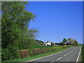
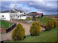
Entrance to Easter Smithstone
The yellow sign says that the garden is open under the "Scotland's Gardens Scheme".
Image: © Gordon Brown
Taken: 22 Jul 2021
0.04 miles
4
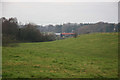
Meltwater channel
The valley present here in the landscape is much larger than is needed by the present stream. Given that the area is covered with till/boulder clay, there would have been much larger volumes of water in the area when the ice retreated at the end of the last Ice Age. It is therefore likely that the enlarged valley was eroded at that time.
Image: © Bob Forrest
Taken: 23 Dec 2006
0.10 miles
5
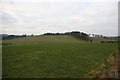
Rolling farming landscape
The rolling nature of the landscape here could be the result of boulder clay being smoothed into drumlin-like mounds as the ice retreated from the Ayrshire plain. Ice pushed in at different times from the Loch Doon region to the south and from the Firth of Clyde to the west.
Image: © Bob Forrest
Taken: 23 Dec 2006
0.24 miles