IMAGES TAKEN NEAR TO
Tarbolton, MAUCHLINE, KA5 5NY
Introduction
This page details the photographs taken nearby to KA5 5NY by members of the Geograph project.
The Geograph project started in 2005 with the aim of publishing, organising and preserving representative images for every square kilometre of Great Britain, Ireland and the Isle of Man.

There are currently over 7.5m images from over14,400 individuals and you can help contribute to the project by visiting https://www.geograph.org.uk
Image Map (Loading...)


Getting Data...Please wait
Leaflet Map data © OpenStreetMap
Images are licensed for reuse under creativecommons.org/licenses/by-sa/2.0
Notes
- Clicking on the map will re-center to the selected point.
- The higher the marker number, the further away the image location is from the centre of the postcode.
Image Listing (5 Images Found)
Images are licensed for reuse under creativecommons.org/licenses/by-sa/2.0
Image
Details
Distance
1
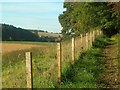
The River Ayr Way
Here the Way follows the edge of Holm Bank, above the Floodplain of Enterkine Holm. Dalmore is visible on the other side of the river.
Image: © Mary and Angus Hogg
Taken: 5 Oct 2007
0.19 miles
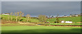
2
The River Ayr Way leaves the B730 north of Stair
Image: © Gordon Brown
Taken: 8 Nov 2008
0.20 miles
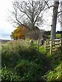
3
Milton of Stair
More accurately, this is the view from Milton of Stair up the slope to the north.
Image: © Anne Burgess
Taken: 25 Dec 2018
0.21 miles
4
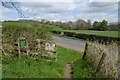
River Ayr Way
Meeting the B730 near Stair.
Image: © Richard Webb
Taken: 22 Apr 2017
0.22 miles
5
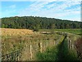
Following An Old Meander
Here the River Ayr Way follows the course of an old meander. No doubt this stretch will be challenging for walkers after wet weather.
Image: © Mary and Angus Hogg
Taken: 5 Oct 2007
0.22 miles